Area 93—moving the county line not so simple
By Virginia Bruce
Update 2/26/13: Washington County has added an information page on Area 93 to their website: http://www.co.washington.or.us/area93

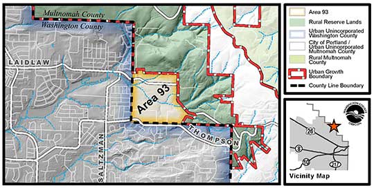
click for a larger version of the Washington County map
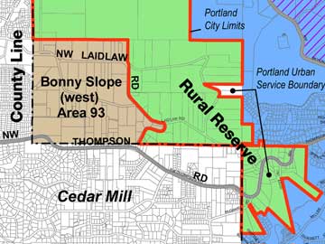
As we reported last November, plans are going forward to move the line between Multnomah and Washington counties so that the area variously known as Bonny Slope West or Area 93 can be planned and developed.
In 2002, Metro decided to bring the roughly 160-acre area into the Urban Growth Boundary as part of a large expansion to accommodate anticipated population growth. It’s been a problem ever since, because Multnomah County doesn’t provide urban services, the area is not contiguous to Portland so they can’t annex it, , and now it’s separated from Portland by Rural Reserve land.
Washington County Chair Andy Duyck feels that the county is in a good position to solve a regional problem. “Some people are questioning the validity of the Urban Growth process. They object to adding more UGB land when areas like this are still undeveloped.” By agreeing to take on the planning and service provision tasks, the county can eliminate this thorn in the side of Metro, and clear the way for development.
He adds, “It cannot be ignored that whether it is next year or next decade, area 93 will develop. This will put a tremendous burden on Washington County roads, with no revenue stream to pay for it if the area stays in Multnomah County. Moving the county line will allow us to control our own destiny.”
 The actual boundary change has to be handled in the state legislature. State Representative Mitch Greenlick has introduced House Bill 2347 to accomplish the change. The bill simply describes the area in question and states that it should be transferred from one county to the other. The actual boundary change has to be handled in the state legislature. State Representative Mitch Greenlick has introduced House Bill 2347 to accomplish the change. The bill simply describes the area in question and states that it should be transferred from one county to the other.
This is the approach favored by the landowners, represented by Dave Hunnicutt, president of Oregonians in Action, a property-rights organization. He says, “The property owners I am working with would prefer that the legislation be simple—change the boundary, and let the counties/Metro resolve remaining issues through intergovernmental agreements. We are certainly not going to interfere with the resolution of any outstanding issues between the counties/Metro, but feel that any resolution can occur without need for legislative assistance, and without resort to holding up the boundary line adjustment.”
Many of the approximately 70 property owners have owned land in the area for a long time, and either live now or have lived on their land. But some of them purchased the land after its inclusion in the UGB, anticipating profits once development began. They are understandably anxious to either pass along their land at a profit, or begin their own projects, once the county transfer becomes final.
But the two counties and Metro are working on a different bill, which will be introduced by State Representative Tobias Read in a few weeks, according to our sources. That bill will include details of the terms of the transfer.
Jim McCauley, Deputy Government Relations Manager for Washington County, says, “It’s not as simple as flipping a switch.” He mentions concerns such as the transfer of voting and land records. “Because it was not a pre-session filing like Rep. Greenlick's bill, it takes a bit longer to refine and move through the process.”
Duyck emphasizes that the bill that the jurisdictions are working on is preferable, because, “Multnomah County and Metro have to be okay with it.”
Chair Duyck says he has spoken to the other members of the Washington County Board of Commissioners and that they are fine with the transfer, in principle. “After the transfer, there may be issues that come up, but the transfer is fine.”
Who will pay
One of the big issues is the funding for needed infrastructure, including roads, sewers, storm water facilities, and water lines. Washington County Commissioner for the area, Greg Malinowski, says, “My message is that it is critical not to burden current residents of Washington County with additional taxes to subsidize the development of Area 93. The Transportation Development Tax has been set by the voters, so that the developers will eventually pay 28% of the transportation system cost that each house adds to the Washington County road system [after the current discounts expire in 2015]. Taxpayers county-wide would ordinarily pick up the other 72%.”
“The landowners in Area 93 will have to come up with a plan for covering most of the cost that the TDT would not cover before development can start. Some possibilities are that the developers or the folks who buy the homes will have to pay either additional System Develeopment Charges, or create a Local Improvement District, or Special Service District. This final piece would have to be determined before we could allow development to start,” says Malinowski.
An early proposal was to create large lots in Area 93. At the meeting in October, Duyck cited the need to provide “executive homes” for Intel and other corporate leaders. Fewer homes would put a smaller burden on existing roads and other infrastructure. However the county’s lowest-density zone is R-5 (five lots to the acre) and nobody seems interested in tinkering with that.
Washington County Planning director Andrew Singelakis says, “At this point, we envision densities at the low end of the range currently permitted under Washington County's Comprehensive Plan and Community Development Code—primarily R-5 and R-6 (which would allow from 4 to 6 units per net acre). That's generally consistent with what's already in the vicinity of Area 93 in Washington County. We'll be working to achieve an appropriate balance from a broad "livability" perspective—not just based on infrastructure needs and revenues.”
He adds, “One of our objectives is to make this change of jurisdiction as close to revenue-neutral for Washington County taxpayers as possible. Existing Washington County residents should not have to pay for public improvements needed in Area 93; those who benefit should pay for them.”
 |
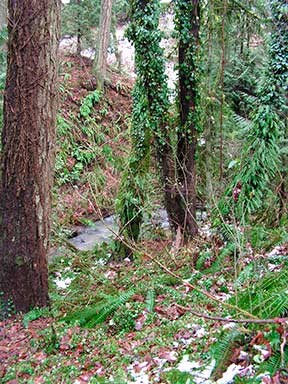
| Steep wooded slopes flank Bronson Creek as it runs through the area |
Steep slopes and stream corridors
Bronson Creek runs through the middle of the area, flanked by steep wooded slopes. When development of adjacent properties is proposed, Clean Water Services (CWS) will require that most of those areas be set aside as natural areas to protect water quality. Some landowners have expressed concerns that they won’t get paid adequately for that part of their land. Tualatin Hills Park & Recreation District, possibly with the aid of Metro funding, will probably acquire portions of it from willing sellers.
THPRD Planning Director Hal Bergsma says, “Wetlands and other undevelopable land (steep slopes, stream corridors) have limited value. The District typically pays about $5,000 per acre for such land, although a higher price might be paid if the land can be restored to a viable wetland or stream corridor allowing the District to receive credit for mitigation of wetland loss in other locations. CWS typically does not acquire land, but THPRD does work with them on natural area restoration projects, which they help to fund.” But, says Bergsma, “Until legislation is approved by the State to change the county line, it will be premature for THPRD to consider acquisition of land in Area 93.”
A wiggly line
The current boundaries between the two counties consists of one-mile stairsteps in this area. But any adjustment will only include the original boundaries of Area 93. “We don’t want any additional rural reserves, and we don’t want to create the suspicion that we’re trying to add to the UGB,” says Duyck.
Representation becomes another question. It is likely that it would be added into CPO 1, and it would definitely become part of Malinowski’s Commission district. Whether it will affect future state and federal districting is just one of the open questions that will have to be answered as a result of this “simple” solution.
|


![]()