 |
Previous Issues |
| Cedar Mill Community Website |
|
Search the Cedar Mill News: |
About The Cedar Mill News |
February 2014
|
|||||||
| Volume 12, Issue 2 | February 2014 |
||||||
Previous article |
|||||||
Neighbors’ appeal puts Glenridge development on hold
|
|||||||
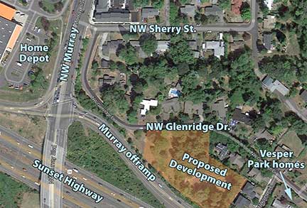 |
Glenridge is a narrow residential street adjacent to the westbound Murray offramp from the Sunset Highway. It had been zoned R-5 (five residential dwellings per acre) up until 1998, when the Cedar Mill-Cedar Hills Community Plan was amended, and the Transit-oriented TO 9-12 designation was applied.
In 1998, a small detached housing development called Vesper Park was approved and later built at the eastern end, where Glenrdge dead-ends. That developer asked for, and was also granted, a hardship variance that allowed them to widen the entire length of Glenridge to only 20 ft. from the previous width of 18 ft.
In 2006, two lots at the west end of Glenridge, bordered on the south by the freeway offramp, were purchased and their houses were later demolished. A neighborhood meeting was held in April 2012, the first step in submitting a development application. Many Glenridge neighbors showed up to listen to Tracy Clark, the developers’ representative, and members of the development team, describe their plans.
One of the attendees was Gene Duncan, a lawyer and former resident who still owns property on Glenridge. Duncan had been petitioning the Washington County Board of Commissioner (BCC) since 2009 to rescind the 1998 upzoning, arguing that the area didn’t meet the definition of a “transitional district” and that the zoning was a threat to property values and quality of life of the current residents.
His request was finally put on the list of potential topics for the 2012 Land Use Work Plan, a document that determines the projects to which county staff will devote time. Staff recommended that it not be included in the Work Plan, stating:
“The planning for Cedar Mill Town Center was a multi-year process that featured significant public input and a number of public hearings. As part of that process, the Glenridge neighborhood was proposed for designation with a land use district that would allow for greater density to accommodate additional population and employment slated for the town center area... A change back to the R-5 designation would have two major consequences: 1) homes constructed under the TO: R9-12 District would become nonconforming uses, and 2) “downzoning” properties from TO: R9-12 to R-5 would increase the county’s potential for Measure 49 claims. These claims can be filed when new land use regulations are enacted after January 1, 2007 when claimants can demonstrate that the new regulations reduce the value of residential property. For these reasons, staff recommends that the Glenridge neighborhood retain its TO: R9-12 designation.”
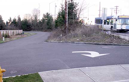 |
| Glenridge Drive at Sherry, Murray on the right |
Aside from property and quality of life values, the Glenridge neighborhood suffers from a significant access problem. At its north end, it intersects with Sherry St. a few feet from Murray. Sherry is “right-out-only” onto Murray, so the only way into the neighborhood is via Joy or Dale off Cornell, and then to Sherry. At Sherry, and for the length of Glenridge, the road is narrow and has no sidewalks except for the portion in front of Vesper Park. Children must use the street to walk to the bus stop on Sherry.
The development application was submitted in July, 2012. Because it was a permitted type of development, it was originally handled as a Type II application, which would only have required a decision by county planning staff to be approved. Andrew Singelakis, Washington County Land Use Director, used his discretion to elevate the application to be heard at a Type III hearing, in an open session before a county hearings officer.
At the hearing in December 2012, neighbors testified about a range of issues including neighborhood compatibility. Pamela Beery, the hearings officer, stated in her approval, “Because the parcel is zoned the way it is, issues of compatibility and home devaluation resulting from the density of the proposed development are not ones which can be addressed by the Hearings Officer.”
The Cedar Mill-Cedar Hills Community Plan, first adopted in 1983 and amended dozens of times since then, includes this statement in its list of General Design Elements:
“5. All new subdivisions, attached unit residential developments, and commercial developments shall provide for pedestrian/bicycle pathways which allow public access through or along the development and connect adjacent developments and/or shopping areas, schools, public transit and park and recreation sites.”
A reasonable person might interpret that to mean that a development like the one proposed should provide a pedestrian/bike pathway to Murray, which is the adjacent shopping and transit area. In addressing that, however, the hearings officer said she “has no legal authority however, to require the applicant to build sidewalks for 600 additional feet to Murray Boulevard, or to serve already existing and more recently approved developments.” She cited the applicants’ intention to put a sidewalk in front of their parcel only.
In approving the variance from the required 22 ft. width, Beery noted the previous decision for the Vesper Park development, which argued that widening the roadway to 22 ft. would “place “at risk” the mature trees located within the right-of-way (ROW) (on the south side of NW Glenridge Drive.” Those trees, however, are mostly located on the current proposed development and are slated for removal.
Once the neighbors found out that Beery had approved the development, they gathered to determine their options. They decided to hire land use lawyer Lance Clark. He helped them form the “Vesper Park/NW Glenridge Drive Neighborhood Association.”
Clark says, ”The big problem was that the design of roads, sidewalks, and pedestrian connectivity typical of the zoning designation did not match the single family home character of the NW Glenridge area, much of it built out in the late 90s through a 15-home plat (Vesper Park) with single family homes, that was approved just before the county rezoned for more density. With narrow, dead-end roads, sidewalks not covering the entire distance between the project and Murray, and very long blocks in comparison to the planned density, the project was not worthy of variances to the development code without mitigation to correct the access limitations. Public safety concerns are obvious.“
He continues, “As I argued before LUBA, the county needs to work on its infrastructure supporting an increased-density neighborhood—such as widening roads and building sidewalks—before allowing projects that ask for variances from things such as the minimum road width for the narrowest road type in the area. The combination of a narrow road with the lack of a continuous sidewalk on at least one side of the street is tough on the pedestrians that the community plan encourages.”
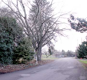 |
| The proposed complex would be located on the left and the trees removed |
LUBA concurred with this argument, and remanded the decision to Washington County. Commenting on the road width, in a footnote the LUBA board members stated, “As an example, petitioner [Clark & the neighbors] points out that the 1998 decision [Vesper Park] relied on an anticipated reduction in the value of the new lots to be developed from the removal of mature trees that would be required to widen NW Glenridge to 22 feet. As we understand it, those trees are either located on the subject property, and will be removed as part of the development, or have already been removed. As a second example, petitioner points out that the 1998 decision found that NW Glenridge has a “country lane” character, and argues that by virtue of the increased traffic on the street resulting from the 1998 decision, [it] has ceased to have that character.”
The Community Development Code (CDC 435-5.3) says that a variance can only be granted if it “will not be materially detrimental to other property in the vicinity.” LUBA said the hearings officer “appears to misconstrue CDC 435-5.3(*C) which requires the hearings officer to determine whether the proposed variance meets that CDC section, not whether the proposed variance is consistent with a variance granted 15 years ago.”
Clark notes, “There was one big finding by LUBA that I consider critical to the outcome and probably the remand. The hearings officer stated the county had no authority to order the developer to pay to widen the road or build sidewalks. I argued that the code allowed for this, citing the specific code provision, subject to takings law proportionality analysis (Dolan and its progeny), and LUBA agreed. It appears that for Vesper Park, while a variance allowed a road below the Code's minimum width, it did require some widening, which I assume the Vesper Park developer paid for.”
Wayne Hayson, the Washington County planner who worked on the application, says, “Essentially, the application hasn't progressed anywhere since the LUBA remand. To move the application forward the applicant has to submit a request to the county to hear the remand, and pay the fee, and to date they have not done so. I do not know what their intention is at this point.”
We spoke briefly to John Inglis, the property owner. He says they do intend to go forward with the development, and that he and his partners are “trying to decide on the two options.” It wasn’t clear if he meant whether they would widen the road or build the sidewalk. We’re not sure that it’s an “either-or” situation at this point.
CPO 1 will receive notice of any action related to Glenridge, so we will keep you posted.
Cedar Hills-Cedar Mill Community Plan
Community Development Code - CDC
Previous article
![]()
Like us on Facebook for timely updates
Published monthly by Pioneer Marketing & Design
Publisher/Editor:Virginia Bruce
info@cedarmillnews.com
PO Box 91061
Portland, Oregon 97291
© 2013