 |
Previous Issues |
| Cedar Mill Community Website |
|
Search the Cedar Mill News: |
About The Cedar Mill News |
April 2013
|
|||||||
| Volume 11, Issue 4 | April 2013 |
||||||
Beaverton and Washington County asked to respond to flood insurance issue
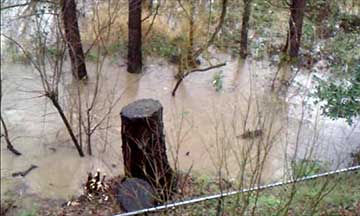
Late in January 2012, a five-year storm led to flooding of the Cedar Mill Wetland adjacent to Barnes Road, which is fed by a branch of Beaverton’s Johnson Creek. Residents of the Sunset Meadows Condominium at the north end of Corby Drive watched the waters rise nearly to the edge of their property. Joe Annett, one of the condo owners, attended a CPO 1 meeting in October 2012 and shared his concerns with the group. One of the reasons the Citizens Participation Organizations exist is to serve as a forum for this type of issue. Joe said that Beaverton, which had annexed his neighborhood in 2005, no longer participates in a Federal Emergency Management Agency (FEMA) program that can enable flood-plain residents to get a discount on their mandatory flood insurance. Very few private insurance companies even offer flood insurance, because the risk pool is not large enough to provide profits. Most flood insurance in the US is provided by the National Flood Insurance Program, which is managed by FEMA. The agency has a program called Community Rating System (CRS) that offers discounts (from 5-45%) on insurance to residents within jurisdictions that participate. CPO 1 voted at its April 2 meeting to send a letter to the Beaverton City Council and the Washington County Board of Commissioners requesting that they participate in the CRS system.
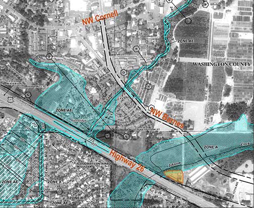
Several areas of Cedar Mill are in 100-year floodplain areas, according to FEMA’s maps. But those maps are old (last updated for Cedar Mill and Johnson Creek in1987) and need to be updated. Washington County, Clean Water Services, and all the local cities contracted with an engineering consultant in 2004-5 to produce new county-wide flood maps. The new flood study and maps were submitted to FEMA in 2005 and have since been under review by FEMA (going on eight years). Once FEMA formally approves them, now anticipated to happen this summer, FEMA will mandate that the local land use agencies—in this case both Washington County and Beaverton— update their codes to incorporate them officially by winter 2014. Jim Duggan, who works in Beaverton’s Development Engineering department, said, “For the Beaverton Creek basin (including North Johnson), the 2005 FEMA FIRM’s (Flood Insurance Rate Maps) show the old 1987 flood study information! What changed for property owners in the Beaverton Creek basin is that the 2005 map preparers used approximate contour mapping from the 1987 flood study and badly superimposed it on an aerial photo from approximately 1994. Prior to 2005, there was no aerial photo in the map. That aerial photo in the 2005 map has since caused many map interpretation errors.” He continued, “The 2005 FEMA maps for the Beaverton Creek basin are so poor that City staff does not consider them reliable for anything more than rough location and the vertical, numerical information. That is why the City of Beaverton has been using its own, accurately prepared maps and the more recent flood study information to communicate flood risk to property owners and to regulate new development. However, for insurance rating purposes, the 2005 FEMA maps must be used per federal law.” In a 1994 memo, Duggan explained that, “Participation in the voluntary CRS program is not exactly an easy task. It takes about 40 work hours to review and complete the yearly application packet and another 60 or so hours to accomplish and document the program requirements throughout the year.” He notes that the city engineering position that had been responsible for those tasks was eliminated during the FY 93-94 budget process, and that’s when Beaverton stopped participating. The “tasks” include improvement projects, public information, additional mapping, and certifying that properties within the floodplain meet certain elevation and other requirements, and that floodplain data is used when approving new development. While Beaverton and Washington County both use floodplain data when considering development applications, both agencies claim that they don’t have the personnel or budget to fully participate in the CRS at this time. In fact, according to Washington County Communications Coordinator Stephen Roberts, no government in Washington County participates in the CRS at this time. Some reasons for this include the relatively small percentage of properties within floodplains (319 homes in Beaverton), the small discounts that would result from low-level participation, and escalating government budget and staff cuts that have been occurring over the last decades. CPO 1 represents all residents of the Cedar Mill-Cedar Hills area, regardless of whether they’ve been annexed into Beaverton. It will be interesting to find out how the city and county respond to the CPO 1 request. This seems like an area where a little more government might be a good thing. NEWS HOME |
||||
Sign
Up Now to receive
|
||||
Published monthly by Pioneer Marketing & Design |