 |
Previous Issues |
| Cedar Mill Community Website |
|
Search the Cedar Mill News: |
About The Cedar Mill News |
|
|||||||
| Volume 14, Issue 5 | May 2016 |
||||||
Cedar Hills/US 26 Offramp Improvements Move Forward
|
||||
 |
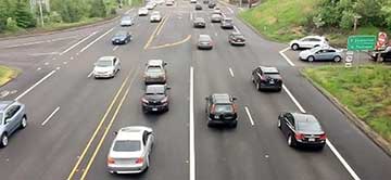
| Looking south at CHB/26, drivers (right) find it difficult to turn left onto northbound CHB. OregonLive writer Joseph Rose included this photo in his item from June 2015, “Beaverton’s intersection from hell: Readers offer up fury, detours and possible fixes.” |
Drivers have learned to avoid the offramp, instead exiting 26 onto Murray, and then using Cornell to reach areas to the north and east. This is one of the reasons that rush-hour traffic on Cornell is so bad.
One reason for the delay in fixing this mess is the question of who will pay for the work. In Beaverton’s Conditions of Approval for the Peterkort family’s Sunset Station & Barnes Road Planned Unit Development (PUD), adopted in October, 2013, the following road improvements are called for at that intersection, based on the increased traffic expected from the development:
At the intersection of CHB and eastbound 26
The other parties had been waiting for the Peterkorts to begin development on their properties, which would trigger the construction of traffic improvements. The economy, the sheer size of the development, and other factors have slowed the company’s progress.
Finally, we hear that an Intergovernmental Agreement (IGA) among the parties involved—City of Beaverton, Washington County, Oregon Department of Transportation (ODOT), and the Peterkort Company—is close to being ready to sign.
Rick Garrison is the Maintenance & Operations Project Manager for ODOT Region 1 (Portland Metro area). He says, “ODOT has completed a review of the initial project scope proposed by Peterkort & Company, and will soon provide a counterproposal to Peterkort, Washington County, and Beaverton. All four parties (including ODOT) will continue to work together to determine if agreement can be reached on a scope and cost of this first phase project, cost sharing responsibilities, and how this first phase project will fit an eventual full buildout of the interchange.”
Don Odermott, Transportation Consulting Group, handles traffic issues for the Peterkorts. He comments, “You are correct that an agreement has been drafted and is under review by all parties. We remain hopeful that design will commence this spring to early summer.”
He continues, “The project anticipates limited ramp intersection improvements at the offramp, including pedestrian facilities at the offramp extending south to Butner. The new offramp signal would be fully integrated operationally with the existing Butner signal, with both signals slated to operate in coordination with the existing traffic signals at the westbound US26 and Barnes Road intersections.”
Washington County controls Barnes Road and Cedar Hills Blvd. while ODOT maintains Highways 217 and 26. The area was annexed into Beaverton in early 2011, prior to the submission of the Peterkort PUD application, which makes them a party to the negotiations.
When could we expect to see the improvements, if the IGA is signed soon? Garrison says, “In early meetings we decided Washington County will take the lead in developing the plans/specifications, and constructing the project. Assuming that we continue in this direction, I do not feel comfortable estimating how long Washington County might need to complete this work or how long construction will take. Three to five years to complete the project is possible, but we need to get closer to completing the agreement and developing a plan for design and construction to be able to give a firm timeline.”
And will this be the final solution, once the Peterkort PUD buildout is complete? Not at all. Andrew Singelakis, Director of Land Use & Transportation at Washington County, says, “It would best be characterized as an interim improvement, and would provide a traffic signal for cars coming from the eastbound ramp off of 26. There will also be some sidewalk improvements in the area. The IGA is for the signal, and each of the parties will contribute $200,000. The County will cover the costs of the sidewalk improvements on Cedar Hills Boulevard.”
Some have advocated for some creative financing solution that would allow the ultimate buildout of both the Barnes/CHB intersection and the highway intersection to the final configuration needed to handle the resulting traffic. Beaverton’s standards might allow for nearly 8.8 million square feet of non-residential development on approximately 65 acres of the Peterkort lands. The PUD is segmented into seven separate parcels, and it’s likely that the traffic improvements required as each segment is developed could keep the intersections torn up and under construction for up to 20 years. None of the parties has expressed interest in such an approach, however.
![]()
Like us on Facebook for timely updates
Published monthly by Pioneer Marketing & Design
Publisher/Editor:Virginia Bruce
info@cedarmillnews.com
PO Box 91061
Portland, Oregon 97291
© 2016