 |
Previous Issues |
| Cedar Mill Community Website |
|
Search the Cedar Mill News: |
About The Cedar Mill News |
June 2016
|
|||||||
| Volume 14, Issue 6 | June 2016 |
||||||
Nollan-Dolan in Washington County
|
||||||
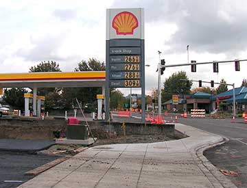 |
| When Cornell was widened, the 12-foot sidewalk was shrunk to five feet in front of the Shell station, anticipating later development that would bring the site into compliance at a later date. With the expansion of the convenience store in 2012, that is now unlikely. |
Many subsequent cases in other parts of the country have gone back and forth between state courts and SCOTUS, refining the situations under which a land owner or developer can sue a jurisdiction for “takings” under the Fourth Amendment. The late Justice Antonin Scalia was fond of a phrase he used in the Nollan opinion—referring to demands by land-use permitting agencies as “extortion.”
Washington County’s decisions are occasionally appealed, but we’re not aware of any “Nollan-Dolan” related cases that have gone higher than the State Land Use Board of Appeals (LUBA). But the threat of losing big (the Dolan case was settled with the city paying Ms. Dolan several hundred thousand dollars) is undoubtedly on the minds of County planners when they look at development proposals.
Here in Cedar Mill, we saw an example in 2005, with the Cornell Road improvement project. When Cornell Road was widened, an exception was made to the 12-foot sidewalks that are required in a pedestrian-oriented Town Center area, to accommodate the Shell station’s existing fueling bays. It had been expected that the sidewalk would be brought into conformation with redevelopment. LUT Principal Planner Wayne Hayson explained that in 2011, when the Shell station expanded and remodeled the building on the site, the cost associated with requiring Shell to relocate their pumps and tanks to allow the full-width sidewalk would not have been proportional to the impact of the development.
Also in 2005, a developer was asked to dedicate right-of-way (ROW) along 113th for a left-turn lane onto Damascus, to accommodate the residents of his proposed subdivision and future developments, and to construct a ten-foot-wide pedestrian access to provide a future connection to NW Valros Lane. He appealed the request and the County Hearings Officer agreed, the land wasn’t dedicated, and the left-turn lane and pedestrian access weren’t built.
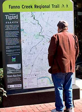 |
| The former A-Boy building in Tigard is now occupied by Pacific Paint & Supply. A segment of the Fanno Creek Trail now runs alongside the property. The City of Tigard leases the land from the Dolan family, according to Tigard Assistant City Manager Liz Newton, who was involved in the case. A sign, paid for by the Dolans, was recently erected on a formerly-blank monument on the property, with a map and information about the trail. |
An even more serious problem seems to exist when it comes to siting public facilities in large developments. You might think that part of the Master Planning process would include setting aside land for neighborhood parks and schools. But in North Bethany and now in Bonny Slope West, the county can only indicate “blobs,” large areas on the plan where they’d like to see such facilities. Zoning land for institutional use only could lead a landowner to decide that the value of their land is being reduced by the county—a “taking.” So school and park districts must use their powers of eminent domain, compete with developers to purchase land, or depend on the good will of developers to sell parcels.
Although Beaverton School District wanted to acquire land in Bonny Slope West for a new elementary school, the only site flat enough for a school already has a land use application submitted to Washington County for a large single-family subdivision. It’s unclear whether any new school property will be acquired during the buildout of BSW, even though BSD has stated that would be desirable.
So even if the good of the many—the larger community and future Washington County residents—would be served by letting planners decide how an area may be developed, property rights, as interpreted under the Nollan-Dolan decisions, mean that developers have been making most of the strategic decisions about how to structure neighborhoods. That has resulted in neighborhoods consisting of seas of houses with few community spaces and no local businesses.
Andrew Singelakis, Director of Land Use & Transportation, points out that North Bethany and Bonny Slope West will be the last large residential master-planning efforts for the county, because under current Urban Growth Boundary regulations, any new additions to the UGB must be adjacent to, and be annexed by, a city.
Nollan-Dolan, however, will continue to be on the minds of urban planners in the area and throughout the country, creating “prior restraint” on decisions involving prescriptive land use. One wonders if even density zoning may be in jeopardy in the future.
1. from Wikipedia: In Nollan v. California Coastal Commission, in 1987 the Court reviewed a regulation under which the California Coastal Commission demanded a lateral public easement across the Nollan’s beachfront lot in exchange for a permit to demolish an existing bungalow and replace it with a three-bedroom house. The public easement was designed to connect two public beaches that were separated by the Nollan's property. The Court observed that requiring a dedication of private property in exchange for a building permit was "out and out extortion" unless it could be shown that the private development imposed a burden on public facilities or resources, and the dedication would mitigate such impact. This became known as the "essential nexus" between a legitimate state interest and the permit condition.
2. from Wikipedia: Then, in Dolan v. City of Tigard, in 1994 the Court evaluated further the degree of the connection required. In that case, the City of Tigard, Oregon required any business owner seeking to expand substantially onto property adjacent to a floodplain, to create a public greenway and bike path from private land in order to prevent flooding and traffic congestion. The Supreme Court ruled that the City’s requirement would be a taking if the City did not show that there was a reasonable relationship between the creation of the greenway and bike path and the impact of the development, and that the exaction was roughly proportional to the impact. "Without question, had the city simply required petitioner to dedicate a strip of land along Fanno Creek for public use, rather than conditioning the grant of her permit to redevelop her property on such a dedication, a taking would have occurred,” the Court held.
![]()
Like us on Facebook for timely updates
Published monthly by Pioneer Marketing & Design
Publisher/Editor:Virginia Bruce
info@cedarmillnews.com
PO Box 91061
Portland, Oregon 97291
© 2016