 |
Previous Issues |
| Cedar Mill Community Website |
|
Search the Cedar Mill News: |
About The Cedar Mill News |
July 2015
|
|||||||
| Volume 13, Issue 7 | July 2015 |
||||||
County refusing to enforce its own rules?
|
||||||||
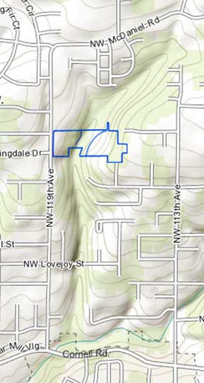 |
| The topographic view of the area shows how the development straddles the tributary of Cedar Mill Creek. |
“Shortly afterwards I was contacted by the owners of Westwood Homes LLC. They explained to me that they were buying all of the property surrounding mine, and they had two possible alternatives to build a sanitary sewer. One was to build a pedestrian footbridge over the creek, much like the existing structure serving McDaniel Village, across from Bonny Slope Elementary to the north of my property. Their other option was to connect to the stub of the sewer line on my property to the south.
[Prior to this development, Westwood had only developed small, infill developments of a few lots each. Some at that time questioned their ability to take on such a large project with so much impacted natural resource area.]
Carver continues, “I called Westwood's representative and told them I would sell them an easement for less than the cost of the bridge. While I would prefer to see no impacts to the natural areas, I will allow it to lessen the impacts.
“When I learned of the full extent of the impacts of this development, that ~96,000 square feet of designated Significant Natural Resource Area (SNRA) was to be destroyed, and that this impact was to be mitigated only by not destroying another 96,000 square feet of SNRA, I decided that the SNRA needed a representative that did not have a financial stake in its destruction.
“I filed appeals with Washington County for the land use decision, and was dismissed out of hand. I took my appeals to the Land Use Board of Appeals, and again was dismissed.
“As part of this development there were originally jurisdictional impacts to two separate wetlands on the project site. Wetland A, which is forested and is completely inside the SNRA, is to be removed. There will be impacts to Wetland B, which is offsite, with a trench that was proposed to access another sewer manhole to the north of the properties, at one end of the existing footbridge.
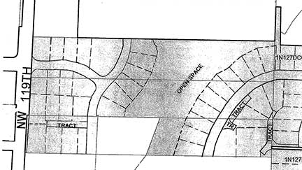 |
| Phase 1 is comprised of the lots leading off 119th, left. |
“In order to fill a wetland, Westwood needed a Joint Removal/Fill (RF) permit from Oregon Department of State Lands (DSL) and the US Army Corps of Engineers. This permit requires that the developer weigh all alternatives that can avoid or reduce the impacts to wetlands against project-specific criteria, to ensure that the project is built in such a way as to avoid impact to wetlands if possible. In their development application, Westwood claimed that there was no way to avoid the impacts to Wetland A due to topography and existing on-site conditions, and that I had refused to sell an easement to access the sewer line on my property.
“DSL granted the RF permit, and I requested a contested case hearing. I sent along emails that proved I had told Westwood I was willing to discuss selling a sewer easement. I also countered that the impacts to Wetland A could be avoided if density transfers were used. [A Density Transfer allows a developer to create smaller lots—denser development—than would be required by zoning—R6, or six units per acre in this case—by putting the total number of units that would be allowed into the area outside the “unbuildable” natural areas.]
“Westwood's engineering firm responded through their Engineering consultant Matt Sprague with SFA Design Group (who is not an engineer) that none of my claims were valid, and I raised no substantial questions of fact. The administrative law judge in charge of the contested case proceedings found that because Matt Sprague has a degree in geography, and has experience working as a planner, that his affidavit asserting that I had raised no issues of fact was enough to grant a summary decision in Westwood's favor.
“Meanwhile Westwood, having all required approval in place, immediately sold the rights to the project to DR Horton, a large national development corporation.
“I had my attorney file for an appeal with the Oregon State Court of Appeals, and then request a stay of DSL's decision pending the outcome of the appeal. At this point DSL recalled its decision for reconsideration.
Carver says, “As it stands today DR Horton is continuing construction of a project in violation of the conditions of approval with Washington County, and Washington County refuses to issue a stop work order to require DR Horton to get its RF permit approved. I have informed the county of this, and they refuse to enforce their own land use decisions.”
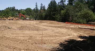 |
| DR Horton is quickly implementing Phase 1 of Cedar Park. The steep stream bank is at the back of this clearing. |
Another neighbor, Michael Scheinfein, contacted Wayne Hayson, the County Senior Planner supervising this application, shortly after Horton began their operations, to ask why LUT was not enforcing its own Conditions of Approval. He believed he was treated rudely, and said he was told not to call back..
Hayson contends that the work on Phase 1 of this development doesn’t require the RF permit. However, the Conditions of Approval requires the developer to, “Provide DSL and Corps of Engineers permits for any work in the wetlands or creek prior to ANY [my emphasis] onsite work, including grading and erosion control.”
It seems to come down to the interpretation of the word “any.” The first two sections of the Conditions of Approval, containing the above phrase, refer to the entire development. Section 3 begins a discussion of Phase 1.
Andrew Singelakis, Director of Land Use & Transportation for the county, says, “Simply put, based on what we know now, County Counsel does not believe we have a legal basis to stop work on Phase 1. County Counsel confirmed that the Court of Appeals does not have a stay pending in this matter. It is our understanding that DSL is reviewing its permit, the focus of which is the wetland removal/fill work in proposed Phase 2. Depending on the outcome of DSL’s review, the applicant may need to modify the previously granted Phase 2 land use approval accordingly prior to commencing construction of that phase.”
We might interpret this to say that the county is concerned about the deep legal pockets of DR Horton. Is this is a continuation of the situation engendered by the “takings” cases (Dolan, etc.), where property owners contend that the planning actions of a jurisdiction may not impinge on the property owner’s right to profit from their land, regardless of the public good?
In any case, Phase 1 of this project is proceeding apace. Even a legal win won’t undo the bulldozers’ work.
Carver said he is likely going to sell his home and move outside the urban growth boundary. The wooded foothills of Cedar Mill are rapidly disappearing as the “economic recovery” promises profits to developers building cookie-cutter houses in the remaining available parcels. If we are looking to the county to slow the pace, or provide alternative patterns of development that preserve more natural areas, we will be disappointed under the current regime.
![]()
Like us on Facebook for timely updates
Published monthly by Pioneer Marketing & Design
Publisher/Editor:Virginia Bruce
info@cedarmillnews.com
PO Box 91061
Portland, Oregon 97291
© 2013