 |
Previous Issues |
| Cedar Mill Community Website |
|
Search the Cedar Mill News: |
About The Cedar Mill News |
August 2016
|
|||||||
| Volume 14, Issue 8 | August 2016 |
||||||
Impacts on land, roads, and open spaces for Thompson Woods
|
||||||||||||
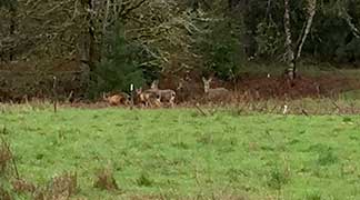 |
| A site visit earlier this year was observed by this resident family |
In June, Washington County Hearings Officer Joe Turner approved the development of 235 homes on 45 heavily wooded, sparsely-populated acres east of Findley Elementary School and between Thompson and Laidlaw roads. To be built in six phases, the development, called Thompson Woods, will generate a number of changes to the land and the surrounding area.
In the coming months, the Cedar Mill News will look at several aspects of project as it was approved, and what to expect from this first large-scale development in what was formerly called Area 93 and now called Bonny Slope West (BSW). In this issue, we will look at the changes to the land and streets from intensively developing this land. We will cover the impact on schools in the next issue.
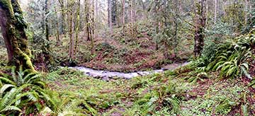 |
| The Ward Creek area was logged so long ago, some of the surrounding woods are almost "old growth." |
Ward Creek runs through the northern part of the forested acres approved for development by West Hills Development (which includes Arbor Homes). It also includes wetlands and “Vegetated Corridors,” which the county notes are Oregon Land Use Goal 5 resources. According to the State of Oregon, “local governments shall adopt programs that will protect natural resources for present and future generations.” West Hills Development will set aside 7.8 acres of its land for these resources, and will remove the rest of the trees to build houses.
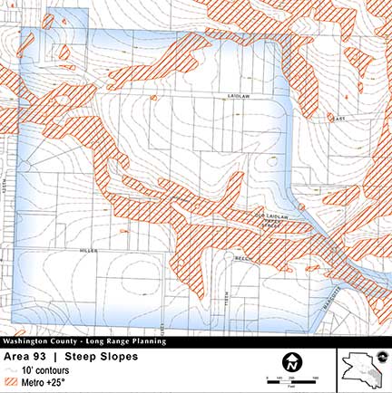 |
| Steep slopes and protected vegetated corridors limit development in BSW |
The Hearings Officer (HO) decision notes that, “clearing and development of this site will eliminate habitat for wildlife. But the Community Development Code (CDC) does not prohibit such an effect. On the contrary, it is an inevitable consequence of concentrating new development in the urban area.” It also said the animals aren’t endangered or threatened, and the fringe of trees along the creek will give animals a wildlife corridor as required.
A state geologist also noted the creek area was “moderate to highly susceptible to shallow- and deep-seated landslides.” The HO decision says, “The applicant has acknowledged the landslide susceptibility identified on these maps and has taken the necessary steps to address this constraint in the preliminary development plans, including the submittal of a geotechnical and geology engineering report.”
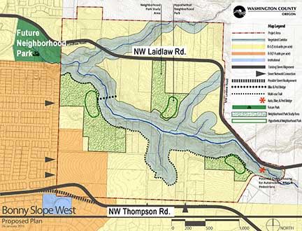 |
| The concept plan for BSW called for a park in the general vicinity of the Thompson Woods development, but THPRD was unable to acquire land for that. |
The 7.8 acres—the “Vegetated Corridor”—to be set aside as a protected natural area, which includes Ward Creek, will be private property, unless the park district decides to obtain it later. Most of the trees will be preserved.
Unlike in North Bethany (NB), parks are not required in BSW. The only requirement from developers is “to have a conversation” with THPRD about land for parks, which West Hills did, said Jeannine Rustad, Superintendent of Planning for Tualatin Hills Parks and Recreation District (THPRD).
County Senior Planner Suzanne Savin, who was involved in the BSW process from the beginning, explains that the Board of Commissioners (BOC) made it clear early on that they didn’t want the BSW planning effort to have the level of detail or the prescriptive requirements of the North Bethany Master Plan. The landowners had waited long enough, after the delay because of the jurisdictional difficulties (transferring the land from Multnomah to Washington County), to realize profits on their land. In addition, BOC members noted mixed feedback from developers and service districts on the North Bethany (NB) process.
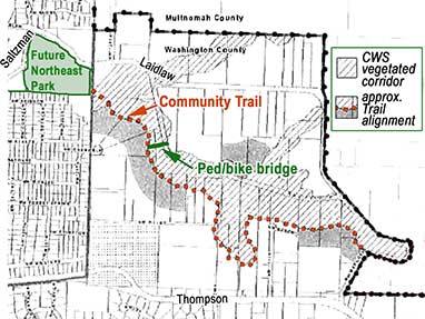 |
| THPRD is asking for a trail alignment that will link to the future park |
Planning staff worked with the County Planning Commission (a board of volunteers who advise the BOC on planning issues) to refine various aspects of the BSW ordinance throughout 2014-2015. Regarding parks, they suggested two possible approaches: a NB-style prescriptive approach; or simply requiring developers to “have discussions with” the park district. The majority of the PC favored the latter. A couple of PC members suggested an alternative approach, requiring a percentage of parkland be created in each development.
In the end, Ordinance 802, which passed in October 2015 and enabled the development of the BSW properties to urban-level densities, calls for developers to “sit down with” park districts in park-deficient areas. (This isn’t required for development in other areas of the county).
Rustad said, and Savin agreed, that it’s possible that the whole of Bonny Slope West could be developed with no parks. She couldn’t comment on negotiations the district may be having with other landowners in the area, outside the Thompson Woods segment. “If you hear of anyone in the area who wants to sell to the park district, send them our way,” she said.
Although West Hills claimed during the hearing that requiring dedication of land for a Community Trail would be a “taking,” (see the Nollan-Dolan article in the June CMN), the HO said there was sufficient “nexus and proportionality” to require it. At one point it was unclear whether that decision would be appealed by West Hills, but the time for an appeal has passed and none was filed, according to planner Paul Schaefer.
The ten-foot-wide paved trail will be constructed by THPRD—at some unkown future date—to connect to the “Future Northeast Park” on property acquired at Saltzman and Laidlaw Roads (Future Northeast Park). The original West Hills proposal showed a trail alignment that didn’t connect to the future park, but Rustad argued, and the HO agreed, that since there was not going to be a park in Thompson Woods, a connection to the adjacent park was necessary.
Some of the remaining buildable land is zoned R-6 (generally six dwellings per acre). West Hills Development plans to build 152 homes on those 33.23 acres. The remaining 83 homes will be built on 11.81 acres that are zoned R-9 (nine dwellings per acre). All houses will be detached. Lot sizes on the R-6 land will range from 4,000 to 7,944 square feet. On the R-9 lots, houses will sit on lots ranging from 2,800 to 4,000 square feet.
Access to the subdivision from NW Thompson Road will be on “Road A,” opposite NW Hibbard Drive. NW Milford Street, NW Brimpton Court, and NW Grenoble Lane in the Bauer Highlands subdivision to the west will be extended into Thompson Woods.
Turner noted in his decision on the project that the addition of potentially hundreds of new drivers on NW Thompson and the surrounding streets would cause additional congestion and delays. “However, based on the applicant’s (West Hills) traffic analysis, the additional traffic will not exceed the capacity of those streets or cause a hazard.”
Some of the nine people who testified at the May 19 public hearing begged to differ, especially regarding construction traffic, some of which will be routed through area neighborhoods. But Turner pointed out that while their concerns were “substantial evidence,” they couldn’t be considered because “they (the residents) are not experts in such matters.”
Washington County Principal Planner Wayne Hayson noted the county code limits construction activities to the hours of 7 am-7 pm, Monday-Saturday. The county has no authority to prohibit construction traffic on local roads. The applicant will be required to repair any roadways or other infrastructure damaged during construction.
Streets within the development will have sidewalks, landscape strips, and streetlights. The only change to NW Thompson Road, currently a two-lane arterial road with no bike lanes, will be the addition of an eastbound left turn lane at Street A and Thompson Road. The developer said at the hearing that they will design the intersection with an eye toward future improvements to Thompson, one of which is realignment to “flatten out” curves in that area. The developer “may participate” in that realignment if the county obtains the needed property within the construction timeframe. The supplemental Transportation Development Tax (TDT) that was approved for BSW will help to pay for the county’s work on Thompson, which will eventually include sidewalks and bike lanes.
![]()
Like us on Facebook for timely updates
Published monthly by Pioneer Marketing & Design
Publisher/Editor:Virginia Bruce
info@cedarmillnews.com
PO Box 91061
Portland, Oregon 97291
© 2016