A publication of the Cedar
Mill Business Association
 |
Previous Issues |
| Cedar Mill Community Website |
|
| About Cedar Mill News |
June 2004
A publication of the Cedar
Mill Business Association |
||||||
|
||||||
| Volume 2, Issue 6 | June 2004
|
|||||
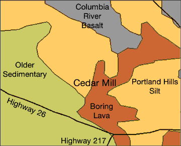
The Nature of Cedar Mill The ground beneath our feetBy Virginia Bruce with information from Scott Burns, PSU Geology Dept.
Cedar Mill is built primarily on two layers composed of basalt and silt, with a frosting of lava on our eastern margins. The underlying rock in our area is Columbia River Basalt. This was laid down by enormous lava flows from volcanoes near the Oregon-Washington-Idaho border around 14 to 16 million years ago. At this time, there were no intervening mountains to slow the flow, which finally solidified here after a trip of some 350 miles. Our dark grey basalt is fairly soft and deteriorates into clay. In Bonny Slope there are only a few feet of soil above the basalt bedrock, as many a developer has discovered. This area is also full of springs resulting from groundwater escaping through cracks in the basalt. Many houses in the area need sump pumps in the basement to remove the seepage. Most of the landscape features in the Willamette Basin were formed by compression resulting from the Pacific plate diving under the continental plate during the last 5 million years. This caused “downwarping and uplifting ,” resulting in hills and basins. The Tualatin Hills are part of an “anticline,” which is a curving formation of uplifted terrain. The layers of silty soil in the Tualatin Valley in areas below 350 ft. are called the Missoula Flood deposits–left on the floodplain during the Missoula Floods. These were a series of some 40 floods around 15,300 to 12,700 years ago, resulting from the rupture of ice dams in the area which is now Montana. Each time an ice dam ruptured vast amounts of water rushed down the Columbia basin and entered the Tualatin Valley near what is now Lake Oswego. Above 350 ft., the silt ("loess") has been deposited by wind and is called "Portland Silt." Probably the most interesting feature of Cedar Mill geology is the existence of lava tubes near our eastern areas. These were formed by the eruptions of three small volcanoes which are located near where Highway 26 goes into the tunnel. One of these volcanoes is called Elk Point, the others are unnamed. They are relatively young, having formed approximately 244,000 years ago. These light grey lava flows are known as Boring Lava, not for their lack of interest but because it was first identified near Boring, Oregon. A lava tube is a tunnel formed when the surface of a lava flow cools and solidifies while the still-molten interior flows through and drains away. One of these lava tubes was found during excavation for St. Vincent’s Hospital in the late ‘60s. It took 6000 truckloads of concrete to fill up the collapsed lava tube to create a stable foundation for the hospital. Gardeners in the area have reported feeling cold air coming out of the ground from cracks in a lava tube. There are several other tubes that open to the surface, but all are on private property. For more information on local geology, visit the library for a copy of Geology of Oregon, by Elizabeth Orr.
NEWS HOME |
|
Sign Up Now to receive |
|
The Cedar Mill News Cedar Mill Business Association Publisher/Editor:Virginia Bruce |