Cedar Mill 2040
by Virginia Bruce, editor
In 1990, Metro, our regional government, began
a study to provide a 50-year planning strategy for regional growth
and development in our area. Metro’s 2040 Growth Concept was adopted
in 1995. For more information about the 2040 plan, see the Metro website
at metro-region.org/article.cfm?ArticleID=422.
According to our Metro Councilor,
Susan McLain, “the next chapter of
the 2040 Plan is to connect with the new people in our area.” The 2040
process involved extensive public discussion, including around 21,000
comments received during the study period. Yet many people either weren’t
here or didn’t pay much attention to the process and its results. “We
need to have a conversation on how we have done in the past decade and
what is next for the plan,” McLain asserts.
 Part of the point of this
planning is to avert “sprawl,” the kind
of development so common in cities around the nation. “If we have significant
greenspaces,” McLain continues, “we should preserve them for
the health of the environment and for our enjoyment rather than build on
them, and increase density in the already-built areas.” Part of the point of this
planning is to avert “sprawl,” the kind
of development so common in cities around the nation. “If we have significant
greenspaces,” McLain continues, “we should preserve them for
the health of the environment and for our enjoyment rather than build on
them, and increase density in the already-built areas.”
This article
attempts to envision what Metro’s plans mean for our area.
We’ll also take a look at plans from Washington County and Tualatin
Hills Park & Recreation District (THPRD).
To get an idea of where we’re
going, it will help to see where we’re
starting from. The population of Cedar Mill was approximately 20,000
in 2000 and this is projected to grow to nearly 40,000 people by
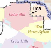
2020.* (For purposes of this article, we’re including the Cedar Mill “Census
Designated Place” and the portion of the West Haven-Sylvan CDP that
encompasses St. Vincent’s Hospital, the Sunset Transit Center and the
Peterkort properties—see map).
Density
To accommodate this increase in population, Washington County has
zoned many areas of Cedar Mill at much higher densities than currently
exist. Around the Sunset Transit Center and in some areas of the
Town Center the zoning calls for 24-40 units per acre. This isn’t exactly
high-rise density, but it’s more than we’re used to. Developers
will be required to build out to this density or show why it’s not
feasible in these areas.
Transportation will be a key issue in our future. The densest areas
are all “Transit Oriented” (TO). From the County Community Development
Code:
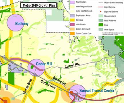 “The
intent of the transit oriented districts is to direct and encourage development
that is transit-supportive and pedestrian-oriented in areas within approximately
one-half mile of light rail transit stations, within one-quarter mile of
existing and planned primary bus routes and in town centers and regional
centers. “The
intent of the transit oriented districts is to direct and encourage development
that is transit-supportive and pedestrian-oriented in areas within approximately
one-half mile of light rail transit stations, within one-quarter mile of
existing and planned primary bus routes and in town centers and regional
centers.
“The purpose of the transit
oriented districts is to limit development to that which (1) has
a sufficient density of employees, residents or users to be supportive of
the type of transit provided to the area; (2) generates a relatively high
percentage of trips serviceable by transit; (3) contains a complementary
mix of land uses; (4) is designed to encourage people to walk; ride a bicycle
or use transit for a significant percentage of their trips.”
Roads
“The work of the county in this century is to build a transportation
grid,” says
Anne Madden, Senior Program Educator in Washington County’s Land Use
and Transportation Department. “Our road system was built on farm-to-market
roads that followed property lines and land contours,” she explains.
Some of the existing routes even date back to native trails (see Elk Trails
and Wapato Paths, Cedar Mill News, February ’05). “On the east
side of the Willamette, they had primarily flat land and when the road system
was built, they just put all the creeks into culverts and paved over them,” says
Madden. We’re
glad that wasn’t done so extensively here, but it has caused a somewhat
confusing road system.
“The County will be working to provide better north-south connections in
the Cedar Mill area,” Madden continues. These improvements will include
a center turn lane on Saltzman from Cornell to Burton that is already in
the works. Improvements will need to be made on 119th/McDaniel to serve the
increased development in that area.
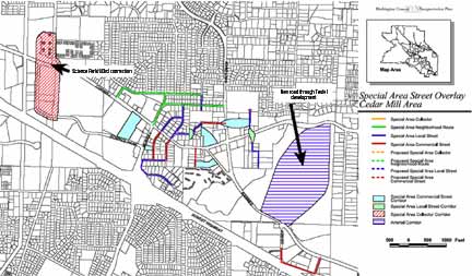 Improvements are also needed in connectivity
in the Town Center area both north and south of Cornell. A proposed
extension of Science Park Drive from Murray to Barnes has been scuttled
due to strong objections from residents. This would have gone a long way
toward alleviating Cornell congestion but the needs of the few won that time. Improvements are also needed in connectivity
in the Town Center area both north and south of Cornell. A proposed
extension of Science Park Drive from Murray to Barnes has been scuttled
due to strong objections from residents. This would have gone a long way
toward alleviating Cornell congestion but the needs of the few won that time.
The county rarely condemns property for road construction. “We do
buy land,” Madden
notes, “and we pay a good price. To condemn property we would have to
make a case that it was imperative, and that hasn’t happened,” she
says. This approach, while it keeps people happy in the short run, can
make transportation planning tricky. “Future development will depend
a lot on private landowners. All we have been able to do is give good opportunities
and work with property owners,” says Madden.
Other improvements in the
works for our area include extending Baltic (the road that goes under
Highway 26 between St. Vincent’s Hospital and Cedar Hills)
northward to the West Haven neighborhood, and making a connection between
143rd and Science Park Drive at Cornell.
More Parks?
Although technically outside of Cedar Mill, there will
be some new park facilities in the Bannister Creek area north of
Laidlaw near Saltzman. The developer has donated a total of 15 acres to the
park, according to Steve Gulgren, Superintendent of Planning and Development
for Tualatin Hills Park & Recreation District.
Trails will connect small tracts among the homes, and playgrounds
will serve families there.
It’s been difficult to find large enough parcels in our area that THPRD
is willing to purchase. Developers often offer small parcels on unbuildable
land. The district used to accept such pieces but no longer is interested
in places that don’t make good parks. Desirable land carries such a
high price tag in Cedar Mill that the District can’t compete with developers.
One area that has a lot of promise is the stretch of Cedar Mill Creek on
the west side of the Teufel Nursery property combined with the land
around the JQA Young house on Cornell. Polygon Homes will improve the streamside
area before donating the land to the district when development is
completed in a few years. This should finally give us a way to enjoy the
exquisite little Cedar Mill Falls.
Some park land will likely be added to the district once the Peterkort
developments are completed around the intersection of Cedar Hills
Boulevard and Barnes. Beaverton’s
Johnson Creek runs through the area, and several acres surrounding the stream
will be improved and donated.
A parcel at the south end of 114th (just west of Cedar Hills Boulevard)
is owned by THPRD and will eventually be added to Foege Park with
an overlook for viewing the Cedar Mill Wetland.
Cedar Mill still needs
a Community Center. The tiny Grange Hall that served the community
in early days is hardly adequate. The district has indefinite plans for some
kind of community center in the area but it’s yet unclear where
we might find a location for this facility.
As developers adopt the “big house, small lot” strategy, the need
for open space and recreation facilities grows. Few developers make room for
these facilities within their neighborhoods, so without the district aggressively
finding more parkland, people are left without places to walk, play and relax
outside.
*Population numbers from Washington County and Metro
|