 |
Previous Issues |
| Cedar Mill Community Website |
|
Search the Cedar Mill News: |
About The Cedar Mill News |
January 2011
|
|||||||
| Volume 9, Issue 1 | January 2011 |
||||||
Bethany Boulevard project sparks controversy, moves forward
|
Project Open House January 27 Sunset Presbyterian Church |
The road is already above capacity, and can be extremely slow to travel during commute hours. Left turns onto the road from the adjacent neighborhoods are very difficult during peak times. Additionally, it lacks bicycle lanes and has sidewalks in only a few sections. Much of it is lined with dangerous and inefficient rock-filled drainage ditches.
As Washington County developed during the 20th century, there were plenty of east-to-west connections leading to Portland, but few robust north-to-south routes, because in the early days, the markets and employment centers were to the east. Over the last twenty years, the county has been striving to upgrade those north-south connections to provide adequate facilities for people to move within the county. Because most of these routes are in developed neighborhoods, widening results in impacts to adjacent properties as we saw along Saltzman, where one house was removed, and several front yards were impacted.
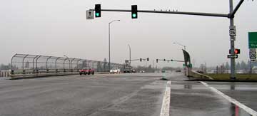 |
| One problem with the project is that the bridge across Highway 26 is too narrow to accommodate five lanes. The county is working with Oregon Department of Transportation to develop a proposal for widening the overpass. |
Initially included in the 1988 Transportation Plan, and confirmed in the 2002 update, the Bethany Road upgrade plans were delayed because of other more pressing projects and financial constraints. The initial project Open House was held on March 30, 2010.
Residents of the adjoining neighborhoods turned out in force to protest the project, because of the loss of one or more homes and impacts to decks, a pool and several back yards. Additionally, they see a five-lane road as an inappropriate barrier to pedestrian travel in their neighborhood. They contend that the traffic information that the county is using to justify the project is faulty. They formed a group called 3not5 and organized a vocal opposition that has turned out at county commission meetings and focus group sessions.
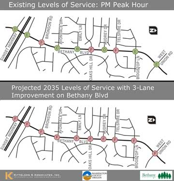 |
| The county cites traffic studies that show that in some places, existing conditions are already failing, and that anything less than five lanes will result in failing intersections within five years. (A is good, F is failing.) |
A Stakeholder Working Group (SWG) was formed last summer with representatives from the affected neighborhoods and other groups with an interest in the outcome. The county also conducted two workshops to inform and gather input: Traffic 101 and Design 101. County engineers and consultants presented information and then small groups of attendees were encouraged to discuss options and design alternatives. Materials from these SWG meetings and workshops, as well as technical reports and the design alternatives, are posted on the W&H Pacific project's website (projects.whpacific.com/bethanyblvd).
The SWG has met six times since June 2010. The next public meeting will be another Open House on January 27, 5-7:30 pm at the Sunset Presbyterian Church (Fellowship Hall/Narthex, East Entrance). At this session, the county will present the four design alternatives (five-lane, four-lane, five-three-five, and three-lane), traffic information, and general project information.
Anyone interested in this subject is encouraged to explore the materials available on the county and contractor websites, which include maps, charts, aerial views, and a comparison chart of the impacts, costs and outcomes of various lane configurations for the project.
The total project is estimated to cost $14.3 million, which will be paid for from the county's general fund, a continuation of the previous Major Streets and Transportation Improvement Program (MSTIP). The construction cost is estimated at around $9.3 million, with the remaining amount going for ROW acquisition, design, and other costs. Project design and ROW acquisition is expected to begin in a few months, with construction slated for summer 2012 through fall 2013.
Published monthly by Pioneer Marketing & Design
Publisher/Editor:Virginia Bruce
503-803-1813
PO Box 91061
Portland, Oregon 97291