 |
Previous Issues |
| Cedar Mill Community Website |
|
Search the Cedar Mill News: |
About The Cedar Mill News |
November 2015
|
|||||||
| Volume 13, Issue 11 | November 2015 |
||||||
Roads and offramps create traffic tangles
|
||||||||
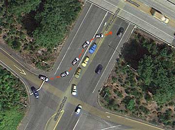 |
| Drivers take chances to turn left from the offramp |
When Peterkort Co. announced their Master Plan for the array of properties around the Barnes-CHB intersection, back in 2004, it was anticipated that ntew developments would eventually pay for at least part of the improvement to the intersection. Oregon Department of Transportation (ODOT) is responsible for the offramp and intersection, but just like Washington County, they have myriad unfunded but needed improvements in other areas. Between the recession and the complexity of handling such a large development, no visible progress has been made on the Peterkort Master Plan.
Recently, however, we have heard that talks are underway to find a solution to the problem. According to Washington County Land Use and Transportation (LUT) sources, “The Peterkort’s traffic consultant, ODOT, Washington County and the City of Beaverton* are discussing a possible public-private effort to fund installation of a signal prior to the future Peterkort development, but there are many unknowns at this time.”
Don Odermott, a Traffic Engineer working with the Peterkort Co., says, “While J. Peterkort & Company has no obligation at this time to fund such an improvement, it is seeking to find a solution as a good citizen and neighbor to address an intersection that has become increasingly dangerous as other development in the community has occurred without funding a solution. We are early in the discussions and are hopeful that a funding proposal and agreement can be reached soon to bring forth a new traffic signal to address the current safety challenges.”
Multiple road improvements will be needed as the Peterkort Master Plan is fulfilled. Rather than build and tear up smaller improvements as each segment comes on line, it has been suggested that ODOT and the county could issue a bond to fund the Peterkort portion of the work, which would be paid off as developers sign on to build parts of the proposed Station Complex shopping center, housing, offices and large retail developments that comprise the Plan.
County representatives claim that the offramp mess doesn’t add significantly to Cornell traffic. “A signal at this location could reduce traffic volumes on Cornell, but not significantly. However, the signal would improve safety at the Cedar Hills Boulevard off-ramp. We understand that some drivers take the Park Way exit from eastbound US 26 near St. Vincent and use Barnes/Saltzman as an alternative way to get to the Cedar Mill area.” Comments on the Cedar Mill News Facebook page indicate otherwise, however.
*By 2011, Beaverton had annexed all the Peterkort properties in this area.
During the hearings this fall on Ordinance 802, which enables the development of “Bonny Slope West,” numerous neighbors brought up the dangerous conditions on Saltzman Road south of Laidlaw, because they believe that BSW will add more traffic to the road.
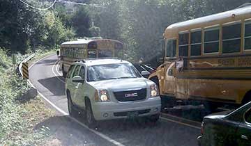 |
| Close calls are a daily occurrence on upper Saltzman |
A major realignment of the road to the west, estimated to cost at least $11 million, is on the county’s recent Transportation System Plan update, but it’s considered a long-term project. “The “ultimate” alignment of Saltzman could be a potential candidate for future MSTIP [countywide transportation funds: Major Streets Transportation Improvement Program] or TDT [site-specific charges to developers: Transportation Development Tax] funding. We are also exploring other options for generating local revenue to help finance this portion of Saltzman Road, such as a Local Improvement District (LID) [nearby landowners would have a surcharge on their property taxes for a period of time],” says the LUT source.”
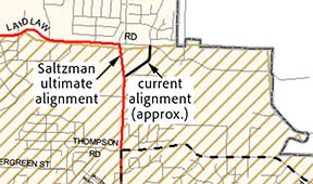 |
| The segment of NW Saltzman Road between NW Laidlaw Road and NW Bayonne Lane is anticipated to be realigned west of the current alignment, to the intersection of NW Laidlaw Road at NW 130th Avenue. The realigned segment of Saltzman Road is designated on the Functional Classification Map as a Proposed Collector. |
Fact Sheet #2 for the BSW Ordinance states, “A $1.2 million pedestrian path or sidewalk and other safety improvements to Saltzman Road are included in the proposed Bonny Slope West transportation funding strategy included in the Infrastructure Funding Plan…this interim project will be funded primarily with developer-paid TDT, and a proposed developer-paid supplemental Bonny Slope West Transportation System Development Charge (TSDC).”
We asked, “What makes anyone think sidewalks and bike lanes are necessary or a good idea? Nobody in their right mind would put their kids on that road, sidewalks or not. Pedestrians and cyclists should NOT be encouraged to use it. Are there regulations that require ped/bike facilities to be included?
LUT responded, “As noted, there are no pedestrian facilities in place on this portion of Saltzman today, but some people do walk, jog, or bike on this section of roadway. We need to consider the safety of all road users, particularly these most-vulnerable users. The proposed interim pedestrian improvement on the existing Saltzman alignment would be a sidewalk physically separated by about five feet from the roadway. A sidewalk separated from the road could help reduce crashes involving pedestrians - by nearly 90%. Separating vehicles and other road users improves safety for all.”
During one of the Ordinance 802 hearings, Chuck Sluyter, who lives on that stretch of Saltzman, spoke regarding project #228 (Saltzman between Bronson Creek and Laidlaw). The minutes state: “He does not support this project. He and his neighbors installed motion activated cameras and have thousands of hours of footage only showing one to two pedestrians per day. The area has inadequate lighting and requests for lighting will increase and cost the residents. Clean Water Services has been dealing with several drainage issues in this area as well and this project will not increase safety, but may increase danger. Some residents have suggested closing this portion.”
Our County Commissioner, Greg Malinowski, said he would only support this project if it is NOT at grade with the road. He does not want children and bikes in the lane with dump trucks.
Originally known as the “Road Through Cornell Gap,” Cornell Road was surveyed in 1868 by a committee who reported that they “proceeded to examine said route and find the same to be one susceptible of making a good road and will be of public utility, will shorten the distance to Portland and will damage no one.” It stretches from the hills of Portland, through the Balch Creek gap, crosses Skyline, and ends in downtown Hillsboro.
Way back in 2002 or so, there was a notion that Cornell would be a pedestrian-friendly street with street-side shops in downtown Cedar Mill. And that’s how the Cornell “improvement” was built. But the truth is, most of the time, it is a highway for people trying to get to one end or the other. Retail hasn’t changed much since then. People from the surrounding areas don’t drive there to walk around in downtown Cedar Mill. Developers pay lip-service to the street-oriented retail concept because they are required to, but it hasn’t led to a vibrant, walkable downtown.
The county responds, “The town center plan is part of a long-term vision. There have been a few developments that support this long-term vision, and we anticipate more.”
We believe that one reason for the congestion during rush hour is the short-sighted and/or unrealistic two-lane construction of Cornell. The county says, “In the County’s Transportation System Plan, Cornell is designated as a five-lane road west of Dale Avenue, and a three-lane road east of Dale. That decision was made by the Board in 2000. It was based on substantial community input following a significant evaluation of several alternatives (five-lane Cornell, three-lane Cornell, three-lane Cornell with a Science Park extension from Murray to Barnes). That decision was made in an attempt to reinforce the town-center concept adopted into the Cedar Hills-Cedar Mill Community Plan.
We asked, “Can Cornell be adjusted to provide another travel lane?”
The county responds, “Cornell could eventually be physically widened to a five-lane facility, but doing so would require an amendment to the Transportation System Plan, the purchase of additional right-of-way (and potentially buildings), and funding for construction. Cornell is just one of many road-capacity needs countywide, and the existing three-lane road conforms to the currently adopted Transportation System Plan.”
What do you think? Will Cornell ever serve as the center of a walkable pedestrian-friendly area? Is that a goal worth pursuing? What could make it happen? Continue this discussion on our Facebook page
![]()
Like us on Facebook for timely updates
Published monthly by Pioneer Marketing & Design
Publisher/Editor:Virginia Bruce
info@cedarmillnews.com
PO Box 91061
Portland, Oregon 97291
© 2015