 |
Previous Issues |
| Cedar Mill Community Website |
|
Search the Cedar Mill News: Search the Cedar Mill News
|
About The Cedar Mill News |
November 2019
|
|||||||
| Volume 17, Issue 11 | November 2019 |
||||||
Development News
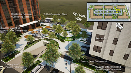
Beaverton Planning approves Cedar Hills redevelopmentOn October 23, the Beaverton Planning Commission reviewed the proposal for the massive redevelopment of the Cedar Hills shopping center, near the intersection of Highways 217 and 26. Urban Form Development Co. is proposing six new buildings with approximately 56,388 square feet of ground floor commercial space, 509 residential units, and 576 parking spaces.
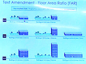
They also asked Beaverton to amend its Development Code to increase the “Floor Area Ratio (FAR)” and the allowed maximum building height in the city’s Station Communities Multiple Use (SC-MU) districts. If accepted, these changes will increase the allowed density in all the Beaverton areas with that designation. FAR is the ratio of total floor space of the buildings in relation to the total area of the lot being developed. Beaverton’s current maximum FAR is 1.00 and the proposal is to change it to 2.00. Basically this means less open space around the buildings. Current maximum building height for Beaverton’s SC-MUs is 60 ft., and Urban Form is requesting that it be increased to 100 ft.
Commission members heard from the Planning Department, the developer team, and several neighbors. As we have noted in the past, Beaverton’s vision for this area is high-density. Neighbors were concerned about the abrupt difference in density compared to the surrounding residential areas, but the planners basically said, “Get used to it.” Neighbors also expressed concern about traffic and parking. Residents will have parking available under the buildings for their exclusive use. Parking in the central areas will be “shared,” with a time limit on resident parking to keep the spaces open for visitors to the commercial spaces during business hours. The new development is just across the skybridge from the Sunset Transit Center, so some residents may choose not to have cars. There’s still a question, however, about whether the MAX system has sufficient capacity to serve increased ridership at this location, particularly with the new Peterkort parking lot coming on line soon. The decision on the development is final. The recommendation to approve the zoning amendments will go to the full Beaverton City Council for approval at a future meeting. Plans have been modified somewhat since we first shared the news of the development. The developer has obtained an option on the former gas station at the northwest corner and is proposing to make that a THPRD park. Construction will take 18-20 months. Several neighbors requested that access to business on Park Way be kept clear during that period.
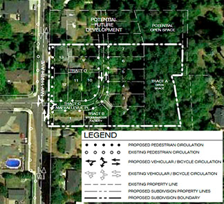
“April Crest” proposed 13-lot development off 119thA neighborhood meeting was held on October 8 to present a proposed residential development east of 119th opposite Vallevue Dr.. PDG Group is representing CTH Investments. The property, slightly over 2.5 acres, is zoned R-6. The eastern side is protected natural area, including wetland and a conservation easement, leaving developable space for 13 lots. Homes will all be on a private street off 119th. A half-street improvement will be built along the east side of 119th, with a bike lane, street trees, and a sidewalk. Once the development plan is submitted to Washington County, it will be open for comments. Two new Laidlaw developments approved
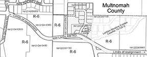
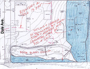
“Laidlaw Meadow” and “Laidlaw Meadow Estates” will add 41 homes to Bonny Slope on the north side of Laidlaw Rd and east of Saltzman. They were done through separate development applications but the subdivisions will be coordinated. Originally approved in August, the decision for the western segment was revised and re-issued on October 30 because of a problem with the connection to 124th. Laidlaw will need to be realigned adjacent to the development to meet county standards. The applicant is required to provide plans for the realignment. Construction may be required if the applicant is able to acquire off-site right-of-way (ROW) from another property owner. If that is not the case, the developer will have to cede ROW and pay “fee-in-lieu” for the future construction. Dale developer requests modification of conditions of approvalA proposal for a 7-lot subdivision at 560 NW Dale Ave. was submitted to the county earlier this year. A hearing was held on October 17, 2019. The applicant is requesting a modification of the Conditions of Approval to change the delineation of the protected area at the eastern side of the property, which includes a segment of Cedar Mill Creek. At issue is the Goal 5 map (see the SNR article). Metro issued maps in 1996 outlining “Goal 5 Resource Areas” to help jurisdictions and developers to meet the state’s requirements for protections of natural resources. The developer contends that the map is wrong and that the protected area should be smaller. The developer submitted a letter from Tim O’Brien, Principal Regional Planner at Metro, who suggests that “the inclusion of a refined local map verification process to verify the specific location of habitat areas” is appropriate in this case.
County LUT staff concurs with this interpretation, saying, “The wildlife biologist generally concurs that the mapped resources are not accurate and should not be mapped as Goal 5 Resource.” They are recommending approval of the development. Some neighbors are concerned that this approach will impact the floodplain and riparian (stream) areas. The property includes a 25-year Drainage Hazard Area (DHA) but the developer and his consultant engineer say that all development will be outside the DHA. Over 13,000 square feet of the property will be set aside as an open space tract, and will be enhanced with native planting, from their current “degraded to marginal condition.” It usually takes several weeks for the hearings officer to respond. We’ll follow up with this when we learn more. Saltzman development approval appealedThe 11-lot subdivision proposed for the west side of Saltzman Road between the two ends of Bauer Woods Drive was approved in mid-October, but we just received word that an appeal has been filed. We have no details. The hearing for the appeal will be on November 21, 11 am, in the first floor auditorium of the Public Services Building, 155 N. First Ave, Hillsboro.
|
|||||||||||
Sign
Up Now to receive
|
|||||||||||
Published monthly by Cedar Mill News LLC |
|||||||||||