 |
Previous Issues |
| Cedar Mill Community Website |
|
| Search the Cedar Mill News: | About The Cedar Mill News |
December 2010
|
|||||||
| Volume 8, Issue 12 | December 2010 |
||||||
The Urban Reserves Memomaps From: Tom Brian To: Roy, Dick and Desari Colleagues: Andy and I have been working with staff, legal counsel, Metro Counselors, and the LCDC director to develop this proposed response to LCDC's decisions (and likely official order). We have reviewed substantial LCDC meeting notes and our staff and counsel have been working with their counterparts at Metro and LCDC to avoid misunderstandings and to hopefully, arrive at a response that is acceptable to our Board, the Metro Council and the LCDC. We apologize in advance for the length of this discussion, but as you know, it is complex and there have been a lot of discussions and meetings in the past month. There is general agreement and understanding that we are operating under the following principles: 1) Per the authority included in LCDC's action, it is our goal to replace Urban Reserves by Cornelius (624 acres) and Forest Grove (28 acres) "acre for acre" and near as practicable. 2) Replacement acreage would be "type for type," in other words, employment land for employment land, residential land for residential land. 3) Replacement acreage will be contiguous to current Urban Reserves, and shall not exceed the gross acreage "lost" as a result of the LCDC decision. Significant natural features, roads, or property lines shall be used as boundaries whenever possible. 4) Current Rural Reserves and Undesignated acres may be modified in order to comply with LCDC's decision. 5) Some members of LCDC expressed concern regarding the small amount of undesignated lands and suggested the County should "look at that" although the addition of undesignated land was not directed. Some also offered that we may have protected too much farm and forest land with Rural Reserves designations that were not necessary. 6) There is general agreement that sufficient analysis and public comment is in the record from which the amendment can be fairly considered; neither Metro nor the County feels it is necessary to re-open the analysis process or conduct an extensive outreach and public information effort. Metro has asked that an amendment to our current IGA with them be amended before the end of the calendar year if agreement can be reached, for the following reasons: a) This action is likely to receive better consideration by the Metro Councilors, our Board members, and staff who have been working on URRs for the past three years (meaning, take advantage of the knowledge, history of the work, negotiating relationships). b) It may be some time before LCDC's order is 'actionable' due to possible appeals, and it would be helpful to the region to have an amended agreement to look to while appeals run their course. c) Property owners would be benefitted to know the direction the region is headed in its response to the LCDC decision. Several owners have offered to have their property included in the modified Urban Reserves and are once again becoming active for that purpose; it would be constructive to inform them whether or not their properties are to be included. d) To achieve an URRs IGA modification as requested, our Board would have to take action on December 14th and Metro Council December 16th. Both agencies are taking steps to preserve that opportunity for their governing bodies. e) Due to the short timeframe, Andy and I suggest the attached draft maps (and explanation that will be available Monday, December 6) be immediately distributed (Monday) to the public (including but not limited to the media, the cities, Metro and interested parties such as the Farm Bureau, TRK, 1000 Friends of Oregon, NAIOP, WEA, our notification list, and other parties).
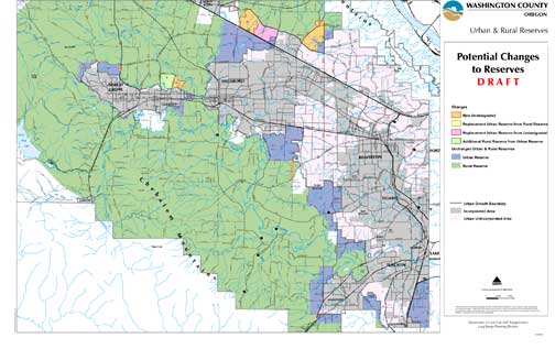
Other Comments: Following our understanding of LCDC's directive, and after discussion with Metro, LCDC and staff, Andy and I set out to determine a draft response to LCDC. LCDC's primary directives were to 1) eliminate all Urban Reserves in area 7 (i), the land north of Council Creek, north of Cornelius, 2) strengthen the findings for area 7 (b), in Forest Grove and north of the Council Creek tributary, or, eliminate some or all of this area if we chose not to strengthen the findings. As to Forest Grove, we recommend eliminating all Urban Reserves east or north of Council Creek, and making the area Undesignated. This is marked as "A" on the revised draft maps and involves 28 gross acres and 16 net buildable acres; it is adjacent to State Highway 47 and Purdin Road. The remainder of the Forest Grove 7 B area would be retained as URs residential land and its findings strengthened per LCDC's suggestion. As to Cornelius 7 (i), the area North of Council Creek. We recommend eliminating all Urban Reserves in this area in compliance with LCDC's directive. This is a reduction of 624 gross acres of URs and 470 acres of net buildable. The area west of Susbauer Road, marked as "B" on the revised draft maps would be designated Rural Reserves. The area east of Susbauer Road, marked as "C" on the revised draft maps would be identified as "Undesignated." Combined, these recommendations would result in a reduction of Urban Reserves of 652 gross acres and 486 net buildable. Virtually all of this land is considered 'employment land.' As to where to locate the replacement acreage, we examined all areas in Washington County that were contiguous to current Urban Reserve designations, and suitable for employment land. Without going into rather exhaustive detail at this time, we eliminated the option of adding the replacement acreage in Sherwood, Tigard, Cooper Mountain, South Hillsboro or South Cornelius. This left the area north of Hwy. 26 and south of West Union Road, and bounded on the west and east by Jackson School Road and Shute Road (now the northerly extension of Brookwood Parkway) respectively. This "rectangle" current includes 88 acres of URs, 585 acres of Undesignated and 632 acres of RRs. Andy and I recommend the following: 1) Moving from east to west, starting with the UR corner piece of 88 acres, change the 585 acres of undesignated and 40 acres of Rural Reserves to Urban Reserves (total replacement acres: 625 as compared to the reduction of 652). These replacement areas are marked as "E" and "F" on the draft revised maps. 2) To recoup the reduction of Undesignated land, continue west and change 592 acres from Rural Reserves to Undesignated. This area is marked as "D" on the draft revised maps. 3) The northwest corner of the "rectangle," adjacent to Jackson School Road and West Union Road, will remain Rural Reserves to serve as a buffer between the communities of North Plains and Hillsboro. This designation was agreed to and considered sufficient by the two cities, Metro and our Board previously. Finally, there is the matter of whether we should add undesignated lands or reduce Rural Reserves designations as referenced by some of the LCDC members. We are suggesting a conservative approach to this. First, we recommend we leave our Rural Reserves designations intact and as currently depicted, other than as modified by item #2, immediately above. We also recommend that we not pursue extensive new Undesignated areas simply to add a few thousand acres of potentially buildable land. We do, however, recommend three additional Undesignated areas: a) The area marked "G" on the draft revised map includes 832 gross acres (515 net buildable acres). This designation could be the location of residential development to support the substantial employment land in the longer term future. It would help provide jobs/housing balance and housing in close proximity to the jobs to reduce commuting miles. It is bounded by three major transportation corridors: 185th, West Union Road and Cornelius Pass Road. The Undesignated status would also assist the County in achieving the ability to improve the intersection of Cornelius Pass Rd., Germantown Road and 185th in the future. This recommendation has NOT been vetted to the extent of the Urban and Rural Reserve considerations and will require further discussion. b) The area marked "H" on the draft revised map includes 67 gross acres (41 net buildable). Undesignated is recommended solely for the purpose of facilitating a future transportation connection from TV Highway (also South Hillsboro/Cornelius Pass Rd.) to Farmington Road. This will enhance connectivity of all modes. This recommendation has NOT been vetted to the extent of the Urban and Rural Reserve considerations and will require further discussion. c) The area marked "I" on the draft revised map includes 9 gross acres (zero buildable). Undesignated is recommended solely for the purpose of facilitating future transportation improvements along State Highway 99 W. This recommendation has NOT been vetted to the extent of the Urban and Rural Reserve considerations and will require further discussion. Area E map: click to download full-size PDF
Overall changes to Urban/Rural proposal map: click to download full-size PDF
Acreage Table: click to download full-size PDF
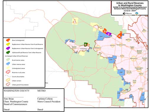
Intergovernmental Agreement (IGA) draft map: click to download full-size PDF
|
Sign
Up Now to receive
|
Published monthly by Pioneer Marketing & Design |