Redrawing Metro Council district boundaries
by Bruce Bartlett, CPO 1 Chair
Our Metro District 4 boundaries are about to be revised. Following the completion of each U.S. Census every 10 years, the Metro Council is required to evaluate whether each of its six districts are of relatively equal population. They must adjust the boundaries as necessary to provide for equal representation. The new district boundaries will be in effect for the next 10 years.
 Census figures indicate that the populations of the Metro Council districts vary significantly from the newly established Metro average district population of 248,362 people. Up here in northern Washington County, the population of District 4 grew to 272,566 people, an increase over the average population of +9.75%, the largest increase in the Metro region. District 4 currently includes the unincorporated urban areas (UUA) of Cedar Mill and Cedar Hills, Aloha, Bonny Slope, Bethany, Raleigh Hills, West Slope, plus the cities of Cornelius, Hillsboro, Forest Grove, and northwest portion of Beaverton. The cities east of Portland in Metro District 6 grew to 253,858 people for a +2.21% increase over the average. All other Metro districts have less than the average population. Census figures indicate that the populations of the Metro Council districts vary significantly from the newly established Metro average district population of 248,362 people. Up here in northern Washington County, the population of District 4 grew to 272,566 people, an increase over the average population of +9.75%, the largest increase in the Metro region. District 4 currently includes the unincorporated urban areas (UUA) of Cedar Mill and Cedar Hills, Aloha, Bonny Slope, Bethany, Raleigh Hills, West Slope, plus the cities of Cornelius, Hillsboro, Forest Grove, and northwest portion of Beaverton. The cities east of Portland in Metro District 6 grew to 253,858 people for a +2.21% increase over the average. All other Metro districts have less than the average population.
The Metro Council is offering three options for public review and consideration. Maps of the three options and other information is available on Metro's website.
The Council will give consideration to existing precincts and, to the maximum extent possible after meeting all other applicable criteria, will maintain communities of mutual interest, such as cities under 15,000 in population, regional centers, town centers, school districts, established neighborhood associations, and community planning and citizen participation organizations.
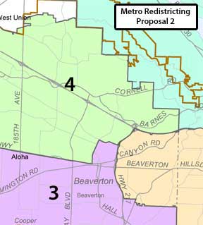
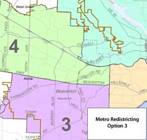
 I spoke with Kathryn Harrington, our District 4 Councilor, who described the challenges of redrawing the district boundaries. When an area is moved from one district to another, corresponding changes must be made somewhere else. Each option responds to different criteria, for example, Option 2 attempts to not divide school district boundaries as much as Option 1. In comparison, CPO boundaries are much weaker decision points. Options 1 and 2 appear to keep all of what we normally consider Cedar Mill (and most of Citizen Participation Organization #1, except for Cedar Hills) in the same Metro council district. I spoke with Kathryn Harrington, our District 4 Councilor, who described the challenges of redrawing the district boundaries. When an area is moved from one district to another, corresponding changes must be made somewhere else. Each option responds to different criteria, for example, Option 2 attempts to not divide school district boundaries as much as Option 1. In comparison, CPO boundaries are much weaker decision points. Options 1 and 2 appear to keep all of what we normally consider Cedar Mill (and most of Citizen Participation Organization #1, except for Cedar Hills) in the same Metro council district.
In addition to what the their charter requires, Metro is also the official federal "Metropolitan Planning Organization" (MPO) for our region. MPOs manage federal investments in the interstate transportation system (as a result of the Federal-Aid Highway Act, signed by President Eisenhower in 1956 and expanded in 1962.) As a condition for receiving federal transportation funding, urban areas with populations of 50,000 or more are to form an MPO to engage in "continuing, comprehensive, and cooperative" transportation planning. (See www.ompoc.org) This requires that the Oregon state MPOs have populations within 5% of each other and so also requires Metro district boundaries be adjusted.
The Metro Council will vote on a final redistricting map on Thursday, May 19, 2011. The redistricting ordinance will contain one preferred map to be introduced at the Council meeting on Thursday, May 12. Public comment is welcome anytime before the final vote on May 19, but comments received before May 12 will be especially valuable in helping determine which map will be introduced with the ordinance.
While comments about specific areas have value, the most valuable comments will be those that consider the impacts to all Metro districts. You can make your views known to the Metro Council by sending feedback to Tony Andersen in the Metro Council office via email at tony.andersen@oregonmetro.gov or through the link on the Metro page. Those comments will be provided to each Councilor and will be included in the public record. You can also send your comments via regular mail to Tony Andersen at Metro Council office, 600 NE Grand Ave., Portland, Oregon 97232.
|
