Planning and Zoning in Cedar Mill
by Anne Madden,
with research from Stephen Roberts & Aisha Willits of Washington County LUT
Oregon has long been viewed as a pioneer in land use planning. In 1969, the state legislature passed Senate Bill 10, requiring each city and county to adopt a comprehensive land use plan and the zoning and land-division ordinances needed to put the plan into effect. However, SB 10 had no accountability mechanism, so in 1973, Governor Tom McCall signed the famous Senate Bill 100 into law. SB 100 established a strong statewide program for land use planning, including the formation of the Land Conservation and Development Commission (LCDC) and the state Department of Land Conservation and Development (DLCD). Under SB 100, DLCD must acknowledge local plans’ conformance with Oregon’s land use planning goals. Cities must periodically review their community plans; counties are not under the same mandate.
Various attempts have been made to repeal all or portions of the state’s land use program. The most successful attempt to date has been statewide Ballot Measure 37, which was promulgated by property rights activists and approved by a majority of Oregon voters in 2004. While very complex, in essence it allowed a property owner to claim compensation from the government if a regulation adopted after the owner’s initial purchase of the property negatively affected the property’s value. As an alternative, the agency that imposed the regulation could waive it and permit use of the property under the regulations in effect at the time of the owner’s initial purchase. Measure 37 was largely replaced by Ballot Measure 49 in 2007 which modified some of the rules; however, certain property owners may still make claims for compensation or waiver of regulations.
Washington County Community Planning
Here in Cedar Mill, since we are unincorporated, our local community plan was drawn up by Washington County - with a fair amount of citizen input, spear-headed by our local Citizen Participation Organization 1 (CPO1). Along with most other community plans for unincorporated Washington County, the Cedar Hills-Cedar Mill Community Plan was adopted in 1983. Since then, it has been amended more than 30 times (not counting modifications to reflect property annexations to Beaverton).
The 2040 Plan and Town Centers
In 1995, Metro, our elected regional government, adopted the 2040 Growth Concept. It is a regional blueprint meant to create thriving neighborhoods and communities, provide economic opportunity, clean air and water, protection of streams and rivers, preservation of farms and forest land, access to nature, and a sense of place. The 2040 Growth Concept envisioned Cedar Mill as a “Town Center.” Town Centers are described as providing “localized services to tens of thousands of people within a two- to three-mile radius. One-to three-story buildings for employment and housing are characteristic. Town centers have a strong sense of community identity and are well served by transit.”
Following adoption of the 2040 Growth Concept, the County amended the Cedar Hills-Cedar Mill Community Plan in 2000 (with Ordinance No. 535) to reflect the land uses, densities, and urban design characteristics envisioned for the Cedar Mill Town Center.
One result of being designated a Town Center was the higher-than-usual level of urban design that went into the rebuilding of Barnes, Saltzman, and, in particular, Cornell Road, as they traverse our community. Note the mostly wide pedestrian-friendly sidewalks, the bulb-outs to aid crossing, the three (not five) travel lanes on Cornell, the landscaping and street trees, and the on-street parking that slows down traffic and makes pedestrians feel safer.
In addition, some residential areas were up-zoned to higher densities, meaning that as property owners choose to redevelop, the neighborhood will change. The higher density development will provide space for the additional residents projected to move to the area. Additional residents should improve our public transit options. Some welcome these developments; some do not.
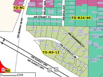 Glenridge Drive Glenridge Drive
One neighborhood in Cedar Mill that is struggling with these changes is the Glenridge Drive community. They have petitioned the county each of the past three years to have Glenridge Drive returned from its current medium-density residential designation back to its pre-town center single-family residential designation. One of their top concerns is how all the extra traffic that would be generated from the envisioned medium-density development would get in and out of the neighborhood, since it currently has only a single right-out-only access onto Murray Boulevard and only indirect access to Cornell They are disappointed that the county is dragging its heels over studying their concerns. The community plan calls for eventual extension of Science Park Drive to Joy for additional access to the area, but that was stalled several years ago and there are no plans to accomplish this anytime soon.
Glenridge residents understand that the county only has so many resources (staff and time) and many requests to review issues like this. Another wrinkle is that the up-zoning increased the underlying value of these properties. Down-zoning would reduce potential values, which could result in impacted property owners claiming compensation from the county for the reduction in value.
Such conflicts of interest are not easily resolved. If you share these concerns, plan to attend CPO 1 meetings at 7 pm on the first Tuesday of each month at the Leedy Grange to learn more.
|