 |
Previous Issues |
| Cedar Mill Community Website |
|
| Search the Cedar Mill News: | About The Cedar Mill News |
July 2010
|
|||||||
| Volume 8, Issue 7 | July 2010 |
||||||
Urban and Rural Reserves
|
 |
| Urban and Rural Reserves in our vicinity. Urban reserves are blue, rural reserves are green. Existing Urban Growth area is pink. The orange circles areTown Centers. |
To be effective, the process required people across the region to consider the interests of the larger community over the long term and to make decisions accordingly. SB1011 stipulates that the counties and Metro must coordinate their Reserves designation process with the region’s cities, special districts, school districts and state agencies. In implementing SB1011, a very diverse group of interests including developers, farmers, foresters, social and environmental advocates and local governments have come together and made recommendations to Metro and the three counties as to which land they would designate Urban and Rural Reserves. Washington County documented this process on their web site.
Under the new law, for the first time planners in the region were allowed to consider where to urbanize based on a broad set of factors for suitability rather the previous approach of choosing land based solely on its soil quality. The law also requires that rural lands be exempt from development for 50 years. This gives farmers and foresters the stability they need to securely invest in infrastructure.
Urban Reserve lands have now been established so that when Metro considers the next UGB expansion later this year, they know where they will look, and the landowners know better what to expect. Originally, over 405,000 acres of land were proposed for Urban Reserves designation. This has been reduced to the 28,615 acres Metro approved for Urban Reserves, with 13,875 in Clackamas County, 13,884 in Washington County and 857 in Multnomah County.
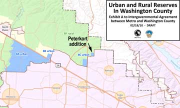
A last-minute wrinkle in the approval process was the requested addition to the Urban Reserves of a 129-acre parcel just north of Portland Community College’s Rock Creek Campus, known as the Peterkort property.
After tentatively approving the Urban Reserves in late February, the Washington County Commission asked to include the 129-acre lot because the owners, the Peterkort family, said they would grant easement on the property to the county for a sewer trunk line and flood plain mitigation only if it were designated as an Urban Reserve. The sewer line is needed to accommodate the high-density growth in the 2002 North Bethany UGB expansion, which is in its final stages of plan approval. County commissioners estimate the inclusion will save taxpayers $2 million and a lengthy eminent domain process.
“We would have purchased the property anyway,” said Tom Brian, chairman of the Washington County Board of Commissioners. “This just saves the county a lot of time and a lot of money.” Brian and County Commissioner Andy Duyck met with Metro Council President David Bragdon and Metro Councilor Collette during the weeklong delay. “We took some time out to answer some questions for Metro and clearly define what this amendment meant to Washington County,” Brian said. They soon understood that this wasn’t a pro-development move as much as it was a pro-environment move, he said.
If they had not been able to reach agreements, all the jurisdictions would have gone back to their historic roles and the old flawed, soils-only-driven system with its political overtones. The results of the work in Washington County are in Ordinance 733, available online at:
www.co.washington.or.us/LUT/Divisions/LongRangePlanning/2010-ordinance-733.cfm
So now we are planning for land development 50 years away when virtually no one making these decisions will be alive; to live with decisions, to feel the inevitable pressure to revise/amend them; the impact of unforeseen developments (for example: another Intel or Nike seemingly falling out of the sky and landing in our backyards or worse, flying away). It is a bit presumptuous to assume that today's decision criteria will be the only ones used in the future.
But given the alternative of uncontrolled growth, (just look at Houston or Las Vegas) our best guesses today are better than nothing. Because Oregon was one of the first states to attempt large-scale land-use planning, we don’t have a guidebook to help us make these decisions. And trends in planning, just like everything else, change over time and with new understanding. Here’s hoping that this latest modification proves to be a step in the right direction.
Published monthly by Cedar Mill Advertising & Design
Publisher/Editor:Virginia Bruce
503-629-5799
PO Box 91061
Portland, Oregon 97291