 |
Previous Issues |
| Cedar Mill Community Website |
|
Search the Cedar Mill News: Search the Cedar Mill News
|
About The Cedar Mill News |
July 2018
|
|||||||
| Volume 16, Issue 7 | July 2018 |
||||||
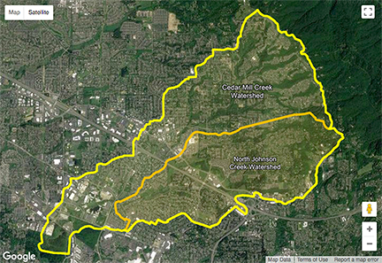
Open House scheduled for Cedar Mill Creek flooding projectWednesday, August 1, 5:30-7:30 pm, St. Andrew Lutheran Church, 12405 SW Butner Road A collaborative effort is underway in Washington County to address flooding in the Cedar Mill Creek/North Johnson Creek watershed. The first step of this multi-phased program is for the Collaborative to complete a Declaration of Cooperation that establishes a roadmap that agencies and jurisdictions will follow to prioritize and fund projects that will help reduce flooding impacts over time. They want to hear from you! Learn more and provide your comments at the August 1 Open House. More information is also available on the project website, which has been updated. Here’s a good background piece from an earlier draft of the “Declaration of Cooperation:” “Cedar Mill Creek and its major tributary, North Johnson Creek, drain a formerly forested watershed on the west side of the West Hills, mostly in Washington County. The creeks flow under US Highway 26 and eventually join near the Nike campus in Beaverton, and flow as Cedar Mill Creek into wetlands to join Beaverton Creek, which meanders west to Rock Creek and eventually to the Tualatin River.
“Development and population growth in the area has increased dramatically in recent decades. The late 1940s saw the first subdivision built in the watershed at Marlene Village. Until the mid-60s, subdivisions were located south of the Sunset Highway, but by 1970, multiple subdivisions just north of the highway were built in the Cornell and Barnes Road corridors, along with commercial development to support the growing population. In the 1980s-1990s, development moved northeast into the West Hills; by 2002 most of the watershed had been developed. A considerable amount of this development occurred before floodplains were regulated and homeowners had access to flood insurance, which started in the mid-70s, and nearly all occurred before modern stormwater management regulations were adopted in 1995. “Today, stormwater runoff patterns have changed in response to urbanization and flooding which is common in the creek corridors, even during relatively small rainfall events. This has exacerbated flooding in low-lying former wetland and floodplain areas that have been developed. Flooding presents major challenges for the community, impacting quality of life and affecting economic activity. “Many of the flooding problems along both creeks have been extensively studied previously…However, to date, a comprehensive, watershed-wide, multifaceted effort to address flooding in the subject area has not been undertaken.” Various subcommittees and working groups have met separately to contribute information and develop approaches for managing flooding and flood-related challenges. Two major categories of activity have emerged. 1) Policies and Programs, and 2) Structural Projects. These concepts will be developed in greater detail in the next phase—after the Project Team adopts the Declaration of Cooperation. That phase will address project prioritization and funding, and an agreed-upon framework for participating organizations to address flooding into the future. Policies & ProgramsSome of the concepts being considered include:
Additional policies may help control the types of development or redevelopment near creeks, such as increased buffer zones or mitigation requirements. That would require jurisdictions to amend zoning and other land use regulations. Structural ProjectsThese are strategies that help manage flooding by building or enhancing public infrastructure along stream corridors. Suggested strategies include:
More work needs to be done before these Policies & Programs and Structural Projects are vetted, prioritized and funded. At the most recent Project Team meeting June 5, the participating agencies discussed the need for a governance structure capable of managing the Flood Mitigation Program in the future. Clean Water Services has been charged with being the coordinating entity for the current effort. New information posted on the project website has several opportunities for more public comment. Even if you have already commented, you’re invited to respond again to help the team craft an approach that will work for everyone.
|
||||
Sign
Up Now to receive
|
||||
Published monthly by Cedar Mill News LLC |
||||