 |
Previous Issues |
| Cedar Mill Community Website |
|
Search the Cedar Mill News: |
About The Cedar Mill News |
August 2012
|
|||||||
| Volume 10, Issue 8 | August 2012 |
||||||
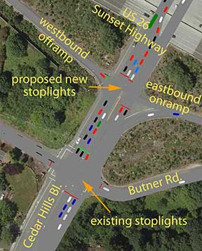
Solving the Cedar Hills / US-26 interchange muddleAnyone who has tried to exit Highway 26 eastbound at Cedar Hills Blvd. knows how difficult it is to turn left/north. It can even be a challenge to turn right/south. Many of us simply avoid it and exit at Murray or Park and find our way to our destination on surface streets. Ian Trout is a Civil Engineering senior at Portland State. For his capstone project* he worked with a team of fellow students, which called themselves Westside Connection, to work on the various problems at this cluster of intersections. The group’s report was published in June, 2012. He explains how it came about. “The project was initiated by a series of complaints/requests submitted by residents of the area to Oregon Department of Transportation (ODOT) Region 1, and the ODOT Bike/Pedestrian program. A letter sent by the CPO 1 Connecting Neighborhoods Subcommittee on March 7, 2011, finally got the attention of the ODOT Region 1 Area Manager. Discussions were initiated within ODOT to explore placing a sidewalk on the eastern side of the interchange (along the underpass) in order to provide safer bicycle and pedestrian connections from Butner Rd. to Barnes Rd. and the adjacent shopping complex. The ODOT project team planned to build the sidewalk during the fall of 2012. “During the discussions, however, ODOT realized the potential conflicts between the proposed sidewalk facilities and future improvements to the US-26-Cedar Hills Blvd (CHB) interchange. The eastbound (EB) off-ramp has posed ongoing operational and safety concerns for ODOT, and is the only off-ramp along the Sunset Highway corridor to be unsignalized (i.e. without a traffic light). So, instead of building the sidewalk on the eastside only for it to be a potential throw-away, ODOT partnered with the PSU team to take a broader look at the interchange area, propose different alternatives, and evaluate them using a number of criteria, including cost estimates and the output of a traffic-modeling software package called VISSIM.”
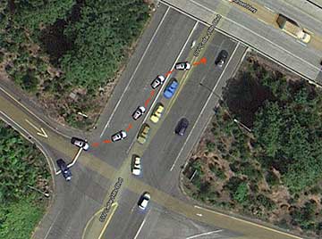
Some of the data that was used for this study was gathered in 2005-2007 by The Transpo Group, hired by J Peterkort & Co. to work on traffic issues for their proposed developments around the intersection of Barnes & CHB. The Level of Service (LOS) score for the EB offramp was an F, and it was assumed for this study that it hasn’t improved. The LOS for the Butner/CHB intersection was a D. Once the data had been assembled, it was run through the VISSIM software to develop analytical tables that demonstrated queue length at the various intersections at peak and average traffic volumes. Crash data from ODOT was also incorporated. During the PM peak (heaviest traffic in the afternoon), the queue (cars backed up behind the intersection) on the EB US-26 off-ramp backs up onto the freeway, causing a safety concern. The southbound (SB) queue on CHB at the light at Butner “was calculated to extend for approximately 204 feet during PM peak hours, which extends beyond the adjacent US-26 EB ramp intersection. This situation is worsened by the long queue that forms in the left-turn lane on SB CHB for motorists trying to turn onto EB US-26. EB US-26 motorists waiting to turn north onto CHB have long wait times and grow impatient, which encourages unsafe driving. A common example, illustrated in the adjacent image, occurs when the motorist turns into the SB travel lanes in order to get around the SB CHB left-turn stack.”
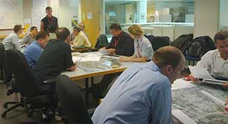
Another design charrette was held at the CPO 1 meeting at Leedy Grange Hall on June 5. This charrette provided an opportunity for the general public to study the alternatives developed in the May session and give feedback. From this input and further analysis, a preferred alternative was chosen. Project cost was a major consideration, including the cost of land acquisition, grading, and road building. Safety for motorists, pedestrians and cyclists was factored in, along with reduction of travel time and the overall “footprint” of the construction project. Data from the various alternatives was input into the software so that all the factors could be analyzed.
The preferred alternative suggests a second SB left turn lane on CHB to US-26 EB, adds a traffic signal that would control that turn lane and the US-26 EB offramp, and creates a longer protected “slip lane” on NB CHB south of the US-26 EB offramp. It includes the east side sidewalk under the freeway, bike lanes, and will undoubtedly require pedestrian “refuges” at points where people need to cross turn lanes. The conclusion of the project report says, “The engagement of stakeholders on the development of this report has led to discussions between the city, county, ODOT, and J. Peterkort and Company. Future development of the land parcels by the Peterkort family will require improvements to the US-26-Cedar Hills interchange.” After studying the report, ODOT commented that, “Representatives from the J Peterkort & Co. have expressed interest with keeping the momentum moving. They’ve requested and ODOT has provided as-built drawings, and they are exploring how they may be able to participate. They are exploring partnership opportunities with the public agencies involved to determine whether an improvement can be implemented sooner than later.” Don Odermott, Transpo Group, says, “The Peterkort development team was appreciative of ODOT's offer to include their input in the mentoring of the PSU student team, and was very pleased with the selection by the PSU students and ODOT of the Cedar Hills Blvd intersection with US-26 eastbound as their choice for the student engineering team's efforts. The Peterkorts have long been aware of the safety and capacity challenges at this intersection, and have spent quite a bit of time and effort evaluating potential improvements for the intersection.” “As a former PSU engineering graduate, it was very rewarding for me personally to give back in a small way to mentor future engineers coming out of my alma mater. The independent review of this challenging intersection, with the proximity of the adjacent signalized intersection with Butner Road, was very rewarding given the time donated by engineers from ODOT, the City of Beaverton, Washington County, Kittelson and Associates, and the Peterkort's consultant team. The Peterkort team was pleased that the result of this independent assessment of alternatives and public outreach affirmed the design solution recommended by the Peterkort's engineering team developed over past years of work in this critical transportation corridor.” * Ian Trout explains: “At PSU, all undergraduate seniors must do a capstone project, which is a six-month community-based project. The whole point of the capstone is to give back to the community and to show what PSU students are doing. As a normal undergraduate student, you would get to choose something from a long list of projects. As a civil engineering student, Professor Tom Szymoniak gave us a list of ten projects and told us to choose our top three. He then assigned us to teams of five people with our top three choices as preferences. The Cedar Hills project was my number one choice.” Jonathan Hangartner, Kaylin McDaniel, Colby Riddle, and Jim Guenther were my team members. Jim Guenther was the only graduate student in our group and was studying for a Masters in geotechnical engineering. Kaylin and Jonathan both got their undergraduate degrees this past June.
NEWS HOME |
||||
Sign
Up Now to receive
|
||||
Published monthly by Pioneer Marketing & Design |
 Once the initial analysis was complete, the group held a series of meetings that involved both stakeholders and the public. During a design charrette (workshop) in May, the PSU team was able to involve engineers from ODOT, Washington County, City of Beaverton, and Transpo Group, who spent two hours developing seven different alternatives. These ranged from “do nothing” to a Single Point Urban Interchange which would combine everything in a massive project. Common improvements in all the alternatives included a sidewalk along the east side of CHB at the underpass, the target of the original project scope.