 |
Previous Issues |
| Cedar Mill Community Website |
|
Search the Cedar Mill News: |
About The Cedar Mill News |
August 2017
|
|||||||
| Volume 15, Issue 8 | August 2017 |
||||||
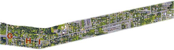
Cedar Mill: Cornell Road runs through it
|
||||||
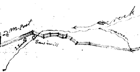 |
| Portion of the original 1863 survey map of Cornell from Washington County files |
In an article in the News from 2004, Cedar Mill historian Nancy Olson wrote, “Originally known as the ‘Road Through Cornell Gap,’ Cornell Road was surveyed in 1868 by a committee that reported they ‘proceeded to examine said route and find the same to be one susceptible of making a good road and will be of public utility, will shorten the distance to Portland and will damage no one.’
“The new route connected with the established Balch Creek Road at the Multnomah County line near William and Emily Cornell’s Donation Land Claim. It proceeded west past the Jones’ cedar mill to join the Old Mountain Road or ‘Hillsboro-Portland Road’ at the modern Barnes-Cornell junction.
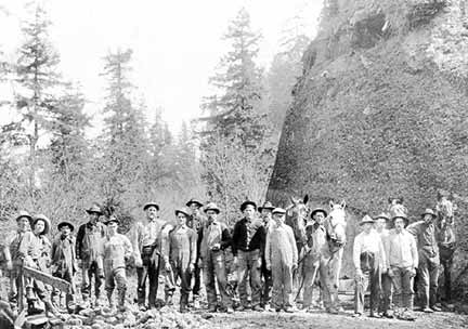 |
| A local crew works on maintaining Cornell Road in 1904 |
“A second survey in 1892 was instigated by Young’s mill to bring more timber to the mill and to provide better access for lumber products to Portland markets. A final survey, prior to building the road, was made in 1901 to avoid so much damage to property owners.”
Washington County classifies the entire length of Cornell, from the county line through Cedar Mill to where it crosses Highway 26 and beyond, as an arterial. “Correctly-sized Arterials at appropriate intervals allow through trips to remain on the Arterial system thereby discouraging use of Local Streets for cut-through traffic. Arterials link major commercial, residential, industrial, and institutional areas” according to the 2015 Transportation System Plan.
The Plan designates the section of Cornell from US 26 to just east of the Murray-Cornell intersection as 3-5 lanes, while the rest of the road, to the county line, is designated as 2-3 lanes. Steve Kelley, LUT Senior Planner, says, “Funding for the 5-lane section of Cornell west of Murray has not yet been identified.”
Paving on Cornell Road between Murray and Bethany boulevards is scheduled to take place Sept 8-Oct. 11, 2018. By re-striping the roadway, buffered bike lanes will be established for safer cycling. It was hoped that the project could be combined with a pedestrian crossing enhancement next to Sunset High, but that project is still being studied.
The approximately $500,000 project will be funded through the “Road Fund” which comes from gas taxes. Washington County receives a portion of state highway funds generated by a 30¢-per-gallon tax on gasoline; truck weight-mile fees; and vehicle registration fees. It generates an estimated $20 million per year for maintenance of the roads under Washington County's jurisdiction.
Washington County also collects a local 1¢-per-gallon fuel tax on gasoline. Anyone who buys gas/diesel in Washington County pays the tax. It generates an estimated $2.2 million per year ($1 million to the county and $1.2 million to local cities) and is used to maintain roads under county (or city) responsibility.
The Murray project widened NW Murray Blvd. from the Highway 26 overpass to Cornell Road. Murray now has five lanes (two through-travel lanes in each direction and a northbound left-turn lane) between 26 and Science Park Drive. Five to seven lanes open up north of there to Cornell: two through-travel lanes in each direction, a southbound left-turn lane providing access into the businesses on the east side of Murray, two northbound left turn lanes and a northbound right-turn lane onto Cornell.
The county decided to combine the project with a signal at Science Park Drive and Cornell. A realignment of Science Park, so that it intersects with 143rd, is on the Transportation Plan as a long-term, $12 million (2014 dollars) project.
The vacant lot that was created when the county purchased the corner for the intersection project will become affordable housing.
In 2004, the county began a major widening project on Cornell between Saltzman and Murray. The Cornell and Barnes Road project limits extended from Murray to Saltzman on Cornell Road and from Saltzman to 119th on Barnes Road. The emphasis was on addressing multi-modal transportation needs by widening Cornell Road to three lanes and Barnes Road to five lanes. The roads were designed with additional improvements including sidewalks, bike lanes, and other features consistent with the goals of the Cedar Mill Town Center.
The project, which took over two years to complete, was disruptive to residents and businesses. The Shell station development was controversial, and included a narrowed sidewalk in front of the station.
Now, according to Steve Kelley, “The three-lane section of Cornell between Murray and Saltzman is congested such that traffic diverts into the surrounding neighborhoods. During the improvement of this section in the 1990s there was a consideration that the on-street parking might someday be converted into a travel lane in the future. The lane number map of the TSP would need to be amended before widening beyond three lanes could proceed (east of Murray).”
We’re not sure what it might take to make this change, but it is a potential partial solution to the congestion that prevents Cornell from functioning as an arterial on this stretch. The aspirations of the Town Center Plan have not materialized, partly due to the lack of guidance that would be available if we were part of a city.
Long-term plans also call for Cornell to be three lanes with bike lanes and sidewalks from Saltzman to the county line. That is one of the reasons that the JQA Young House at Cornell and 119th will need to be moved back on the lot, since the county’s right-of-way (needed for bike lanes and sidewalk) extends nearly to the front porch! No funding or timeline is planned at this time.
When Cedar Hills Boulevard was extended from Barnes to Cornell, one of the old-growth cedar trees that was cut down for the project was carved into a totem pole by artist Rick Bartow. After being displayed in the White House garden in DC for a while, the pole returned to a small park at the corner of Cornell and 113th.
Various small projects have created paved walking paths and sidewalks along Cornell east of Saltzman but the system is far from complete.
In a 2006 article, we wrote, “Nancy Scheewe, owner of DuFresne’s Auto Service at 107th and Cornell, has been worried for years about the dangers to motorists and pedestrians at the intersection. She has witnessed everything from fender-benders to serious accidents. “We’ve had really bad ones from first-time drivers, to motorcycles, to people sliding down the street on wheels only – no tires! Speed has a lot to do with it, with drivers trying to beat out the cement truck or something. Of course, increased traffic plays a big part in it. Now, with the new development just west of us, it will be even worse,” she says.
107th serves as a connector for the residential areas to the south in the West Haven area between Barnes and Cornell. Scheewe notes, “When it gets busy, drivers use our lot as a cut-through. We’ve seen as many as three cars at a time. It is really serious as little kids are often present.” Cedar Mill School is just up the road at 102nd.
Greg Miller, [then] Washington County Engineer, says, “This intersection is very close to meeting warrants for a signal now. Warrants for turn lanes westbound on Cornell and northbound on 107th are met now. We have recently requested updated traffic counts and will be happy to share those when we get them.”
He continues, “a signal is not all that is required at this intersection—it also needs turn lanes on Cornell and a second northbound lane on 107th south of the intersection. Right of way will also be required. These sorts of improvements typically cost $5-600,000, sometimes more.”
Miller went on to say that the county expected a future developer to pay for the work. Then we had a recession, and nothing was developed. Now, 11 years after that was written, the project is on the county’s schedule, to begin in 2018.
Project description: The busy intersection of Cornell Road and 107th Avenue is currently offset and not signalized. This project will realign the intersection and install a traffic signal, which will include dedicated left turn lanes on Cornell Road for travelers turning onto 107th Avenue.
As part of this project, continuous bicycle and pedestrian facilities will also be extended along Cornell Road from 107th to 102nd. Additional improvements include street lighting, storm drainage upgrades and landscaping. Project limits are subject to change upon further design review.
This $3.85 million project is funded through a combination of sources including the County's Major Streets Transportation Improvement Program (MSTIP) and state funds. The total project cost includes the estimated cost of design, right-of-way and construction and is subject to change.
This project is currently in the preliminary design phase. Surveyors and other crews will be on site gathering data in order to initiate design. Construction is scheduled for 2018.
![]()
Like us on Facebook for timely updates
Published monthly by Pioneer Marketing & Design
Publisher/Editor:Virginia Bruce
info@cedarmillnews.com
PO Box 91061
Portland, Oregon 97291
© 2017