 |
Previous Issues |
| Cedar Mill Community Website |
|
Search the Cedar Mill News: |
About The Cedar Mill News |
September 2015
|
|||||||
| Volume 13, Issue 9 | September 2015 |
||||||
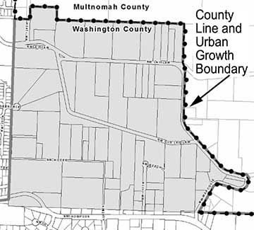
Bonny Slope West updateWashington County is continuing the process of community planning that will clear the way for developers to build up to 600 new homes on the 160 acres of land formerly known as Area 93. Two ordinances (802 and 803) were considered during the Board of County Commissioners (BCC) meeting on September 1. These ordinances establish land use designations and development regulations for Bonny Slope West (BSW). At a public hearing during the September 22 meeting, the Board is expected to amend the ordinances. Additional hearings will then be held at BCC meetings in October. The project timeline calls for the commission to adopt the final plan this fall.
Several issues are drawing comments from residents, public agencies and developers. One thing that concerns some people is the cost of improving transportation infrastructure to handle increased traffic. Developers will pay most of the costs for internal roads in their developments, but some argue that the Transportation Development Tax (TDT) required for offsite impacts to the road system won’t begin to cover the impacts. The TDT is currently set at about 28% of the real cost to improve roads countywide to handle the increase in traffic. Taxpayers absorb the rest (or the roads don’t get improved, which is what has been happening to a large extent). The BSW website states, “Washington County's objective is to make this change of jurisdiction as close to revenue-neutral for its existing taxpayers as possible. Existing Washington County residents should not have to pay for public improvements needed in Bonny Slope West—those who benefit should pay for them.” That statement leaves out the impacts on the surrounding areas.
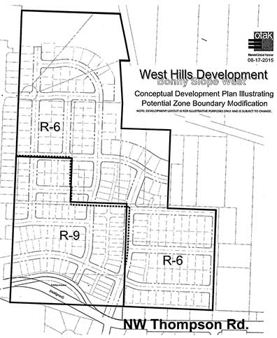
Another concern is the impact on area schools from the estimated 460 students who will live in the new homes. Students are expected to attend Bonny Slope Elementary, Cedar Park Middle, and Sunset High schools. Those schools are already somewhat crowded, and while BSD anticipates a need for an elementary school site in BSW, the district does not have funding to purchase a school site at this time. School boundary adjustments are likely, but that will lead to more busing, among other bad effects. Providing parks for the new residents is another concern. The Tualatin Hills Park & Recreation District’s 2015 Parks Functional Plan calls for “a minimum of one or two parks” in BSW. The original plans noted several locations for parks, based on “visual and physical access to Ward Creek, proximity to anticipated densities, barriers to access…and needs based on gaps in service to the area.” The county Planning Commission narrowly recommended (5-4) removing those designated locations from the map because of concerns about private property rights, among other things. Both Metro and THPRD have responded that these designated areas should remain. THPRD Superintendent of Planning Jeannine Rustad stated in her letter of testimony that, “The map, which resulted from the public outreach process, illustrates the most appropriate/desirable areas for parks. It is unclear how removing this map will bolster THPRD’s ability to negotiate for park sites.” She also stated that the district typically pays fair market value for land it acquires. Another concern is that BSW has significant areas of landslide hazard, and also sits near the Oatfield Fault. Although developers could build homes in these landslide hazard areas with the blessing of a geotechnical engineer, it is unclear as to whether engineering standards can trump mother nature. It’s been suggested that those hazards should be noted on the deeds that the eventual homeowners would receive, and developers are concerned that the information would diminish the potential selling price. Suggested zoning for the area includes both R9 (nine homes per acre) and R6. Developers expect to build their typical “big houses on small lots” that we see everywhere (see West Hills concept plan). Some people have suggested that the same net number of dwellings could be reached by increasing the amount of open space (for parks, gardens, and green space) and packing the dwellings more tightly, with shared walls which create more energy-efficient buildings. Studies are showing that millennials are increasingly attracted to that kind of housing. Developers, however, are notably reluctant to try anything new. Too bad. It’s certainly too late to stop the current plan. It will very likely be voted for by the developer-friendly BCC majority, if not by the whole commission. But maybe we can take some lessons for future planning, so that Washington County might eventually get out of the habit of building “more of the same” forever.
|
||||||
Sign
Up Now to receive
|
||||||
Published monthly by Pioneer Marketing & Design |
||||||