 |
Previous Issues |
| Cedar Mill Community Website |
|
| About Cedar Mill News |
January 2009
|
||||||
| Volume 7, Issue 1 | January 2009 |
|||||
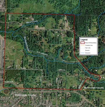
Area 93/Bonny Slope West planning process beginsBy Virginia Bruce Metro is the tri-county regional government that controls growth in our area, among other responsibilities. Since the late 1970s, when Oregon’s new land use laws called for controls on urban growth, it has been responsible for additions to the Urban Growth Boundary (UGB) in the region. In 2002, an unprecedented 18,867 acres were added to the UGB. In addition to well-known parcels such as Bull Mountain and North Bethany, a roughly 160-acre parcel called Area 93 was included in that UGB expansion. Now known as Bonny Slope West, the land is in rural unincorporated Multnomah County, west of the City of Portland. It is bordered by rural, unincorporated Multnomah County on the north and east and by urban, unincorporated Washington County to the south and west (see map).
The area is 3/4-mile west of Portland’s Urban Service Boundary (USB) which defines the area where the City has current plans to provide urban services. The closest Portland city limit is the western margin of Forest Heights, and it is separated from Bonny Slope West by steep slopes. (see Vicinity Map) And therein lies the rub. Under current laws, Portland can neither annex nor provide services to Area 93. Some years ago, Multnomah County transitioned urban services to its cities and thus does not have the capacity to provide services or administer urban planning and zoning designations. Even though the area is within the UGB, development can’t take place without a Master Plan developed by either a city or county. Some jurisdiction needs to decide such questions as who will provide urban services like water and sewer, who will govern the area, where roads will go, and what land will be excluded from development to protect natural resources. In addition, because of the geography, the logical service providers to the area would be Washington County providers like Clean Water Services, Tualatin Valley Water District and the Beaverton School District, which operates the nearby Terra Nova High School. And residents of the area once it’s developed are more likely to shop in Cedar Mill and Bethany and use Washington County roads. Finally in early 2008 Metro agreed to provide Multnomah County with a $200,000 grant to facilitate a planning process using consultants and with participation from officials in both Portland and Multnomah County. An open house for the project was held in October 2008, with a roomful of local residents, frustrated landowners, and developers who have been waiting for progress.
Developer and real estate agent Brian Nelson, who owns land in Area 93, puts it this way. “No one that I know that is involved is pleased with this slow planning process. I feel that by including this area in the UGB expansion Metro had an obligation to ensure the planning was done in a timely manor. Metro and Multnomah County have let all of the local property owners down by delaying the planning process. In 2004 Metro had the power and should have increased pressure on Multnomah County to start the planning. It has been six years since Area 93 was brought into the UGB. The planning should have been completed and the area ready for development by now.” Last month a draft “opportunities and constraints” report was issued, prepared by Winterbrook Planning for the City of Portland. It’s available online on the Portland website: portlandonline.com/planning/index.cfm?c=48729. The report covers existing conditions, an analysis of constrained and buildable lands, and the consultants’ conclusions about possible outcomes for the planning process.
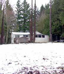
Current conditionsThe area is bounded on the north and east by Laidlaw Road, and on the south by Thompson. There is no sewer—residents have their own septic systems. A few lots get water from Tualatin Valley Water District, but many residents have their own wells. The south fork of Bronson Creek runs through the middle of the area from east to west in a steep ravine, typical of a headwater stream in this area. It eventually joins with Beaverton Creek and thus to the Tualatin River. There are approximately 40 residents currently in the area, living on mostly one to five acre parcels. Structures range from unoccupied crumbling shacks to high-end custom homes. There are 69 tax lots held by 52 separate owners. The largest single-owner assembly of lots is a vacant, 11-acre parcel at the western edge of the area adjacent to the Washington County subdivision off Saltzman, and the consultants’ report notes that it is a key redevelopment opportunity. Many other lots were bought up by speculating developers shortly after the area was brought into the UGB and are either rented or remain vacant. The name Bonny Slope is from a subdivision by that name platted in 1923. The west half of the historic subdivision (see Cedar Mill News, July 2006) covers most of the plan area. The land use pattern is semi-rural, but there are no active farms in the area.
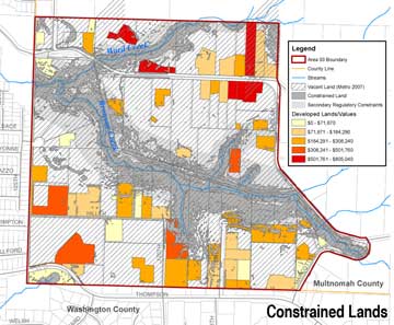
Constrained landOf the almost 160 acres in Area 93, much of it is considered “constrained,” because of environmental or regulatory issues or because of existing development. Although many homes sit on large lots that are considered partially vacant, it’s not expected that people with high-value houses will subdivide, so the consultants used a building value threshold of $250,000 for partially vacant parcels (see Constrained Lands map). Some landowners dispute the consultants' valuations, however. 32 acres have 25% or greater slopes; 18 acres have stream and wetland protection; 39 acres are already developed. Some of these areas overlap, so the net constrained land comprises a little more than 70 acres. An additional 19 acres are constrained through Metro and Multnomah County designations as being high-quality habitat conservation areas, leaving a total of about 70 acres of land that is at least somewhat suitable for future development. Providing urban servicesThe consultants’ report says, “The most significant infrastructure constraints are that Area 93 is not currently within a water or sanitary sewer district and the water and sewer districts that could most easily serve Area 93 are primarily Washington County service providers.” Sewers need to either run downhill or be serviced by pumping stations. Clean Water Services is controlled by Washington County, so some kind of intergovernmental agreement would have to be reached to allow service provision.
The area is already served by the Beaverton School District and by Tualatin Valley Fire & Rescue, both essentially Washington County agencies. Law enforcement and protection services are provided by the Multnomah County Sheriff’s Office, with one officer from the Sauvie Island/District 10 office to cover approximately 67 square miles in western Multnomah County. Tualatin Hills Park & Recreation District (THPRD) has acquired about seven acres at the southwest corner of Laidlaw and Saltzman (see article next page) just over the border at the edge of Washington County. THPRD Director of Planning Hal Bergsma says, “It is possible for THPRD to acquire land outside its boundaries and outside Washington County. We would be willing to work with other agencies and willing property owners to help preserve natural areas in the upper Bronson Creek area, including land in Area 93.” Bronson Creek has been identified by Metro as a high-priority natural corridor, and a trail is envisioned that would link Forest Park with the Tualatin Valley. Density and impact on Cedar MillIn general, areas brought into the UGB are expected by Metro to be developed at a density level of ten dwellings per net developable acre. Portland Lead Planner Brian Sheehan says that there are too many variables to know whether this minimum density level is achievable, although some density is necessary to provide enough tax revenue to pay for the necessary infrastructure improvements. Questions such as whether the area can also support some commercial development, and where the density will go, will be explored by the team of consultants. If this density is ultimately achieved, we can expect to see some 700 new residences added to our northern margins, with the resultant traffic impacts on Thompson, Laidlaw, Saltzman and McDaniel as residents head for work and shopping. The consultants who wrote the preliminary report made some interesting comments about the best way to develop the area. They suggest clustered development with larger common open spaces. This helps protect the natural environment as well as saving on infrastructure costs—fewer roads, more centralized utilities. They also noted that it is unlikely that the area could support the kind of mixed-use, residential and commercial development that has become popular in recent years for providing walkable communities. This means that residents would be car-dependent for everything.
Next steps and possible outcomesPortland’s Planning Bureau is now looking for a firm or a team of consultants to provide a conceptual plan that will recommend options and analyze costs for the development of Area 93. It sent out a request for proposals in December and will review the applications along with Metro and Multnomah County, hoping to pick a provider by the end of January. That consultant will study options and conduct public outreach and is expected to work through 2009 on these tasks. A final service option must then be selected and implementing land use ordinances adopted before the area will be development-ready. This last step of the planning process is expected to occur by January 1, 2011 and will coincide with region-wide decisions about how and where the Urban Growth Boundary (UGB) should be expanded in the future. Several possible scenarios are being discussed. Options may include future annexation to Portland with city services, annexation to Portland with services provided by districts, or service by the County and districts. There has even been discussion of a land transfer to Washington County, but it’s unlikely that either Portland or Multnomah County would want to lose the land (although they may want to lose the headaches). Lessons learnedSome planners at Metro have privately expressed regret that Area 93 was brought into the UGB because of the problems with governance and service provision. In the current effort to identify Urban and Rural Reserves, governance and service provision are top priority questions to ask about potential additions. Visit Portland’s website at portlandonline.com/planning/index.cfm?c=48729 for ongoing information about Area 93/Bonny Slope West. Visit Metro’s website at metroregion.org and search for “UGB” for additional informative background on the UGB. Maps are from Winterbrook Planning December 2008 report NEWS HOME |
||||||||||||||
Sign
Up Now to receive
|
||||||||||||||
Cedar Mill Business Association Published monthly by Cedar Mill Advertising & Design |