 |
Previous Issues |
| Cedar Mill Community Website |
|
| About Cedar Mill News |
June 2009
|
||||||
| Volume 7, Issue 6 | June 2009 |
|||||
North Bethany expansion raises many questions
|
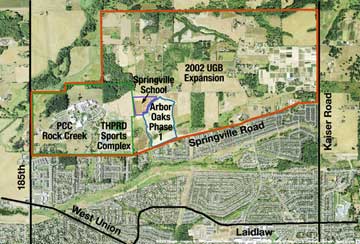 |
| Click on image to enlarge |
Nothing exemplifies this better than the process by which many of the lands brought into the Urban Growth Boundary (UGB) are being planned for development. Washington County was given the responsibility of building communities on 800 acres in North Bethany, and 400 acres in West Bull Mountain, while Clackamas County got responsibility for 12,000 acres in the Damascus areas and Multnomah County/Portland got responsibility for a frustratingly small 160 acres in Bonny Slope. Each of these areas has their own story—and none are pretty, or successful at this point.
When the population was small, growth just seemed to fit into the overall picture and its costs were obscured. Early on, the county approved any development for which critical services (water and sewer) could be provided by the developer. Roads were generally not an issue and from the start, development never fully paid for its transportation needs. This is a key fact to understand. We have always been in a “catch-up” mode. The funding to create or expand major regional transportation routes has been historically addressed through general funds or levies with all residents in the county paying for new infrastructure, whether they directly benefited or not. The same essential situation exists for schools too.
 |
| Panoramic view of North Bethany from Brugger Rd. looking south. THPRD sports facility at far right, Arbor Oaks center right. Photo by Neil Hefty |
In part, the dilemma is caused by Washington County’s reasonable policy of not funding urban services that are not available to all residents of the county, with the expectation that cities would be formed or expanded to provide those urban services (“County 2000” plan). It is a solid, well thought-out policy but it has not been fully implemented. Urban developments have never been required to be part of a city to be built, and a huge urban unincorporated area (UUA) has resulted. When the UGB was established in the early 1980s, land far from city boundaries was included. In order to accommodate the property rights of the owners, development was not blocked if critical services could somehow be provided. Now, if the UUAs were to be incorporated into a single city, it would be the second largest in Oregon with a population of over 220,000. This is hardly the result of a set of well-executed land use laws and county policies.
Special service districts were formed in the UUA to provide water, sewer, schools, parks, road maintenance and public safety. While these service districts can levy taxes to cover operating costs, the impact of growth often requires an additional tax to be levied for capital expansion. This is particularly true of fire protection and schools. Without serial levies and bond measures, no more schools or fire stations would be built.
Oregon’s population has increased rapidly in the last 50 years, with Washington County leading the way. Starting with a population of about 50,000 in 1950, the county now has over 550,000 people. Recent projections by Metro indicate the strong likelihood of another doubling of the population by 2030. It makes sense to try to plan for this. Let’s look at the situation in North Bethany.
In 1998 about 100 acres were requested to be added to the UGB on NW Springville Road adjacent to Portland Community College’s Rock Creek Campus. The proposal for the Arbor Oaks development was very contentious—it was approved but then appealed and remanded back to Metro. That same land was brought into the UGB in 2002 as part of the 800 acres now called North Bethany. At the time, Beaverton and the county had an intergovernmental agreement (IGA) that Beaverton would draw up the master plans, provide the permits, and ultimately annex it. Three years of legal battles followed. In September 2005, the Oregon Court of Appeals rejected a challenge to its inclusion and cleared the way to transform North Bethany from rural landscape to a densely developed ”Urbania”. With the coincident, colossal failure of the Beaverton Annexation Plan in 2004/2005, Beaverton was removed from the Bethany planning effort and the county became the owner of the process.
About this time, Metro instituted a development application fee surcharge to provide funding to plan the 2002 UGB expansion areas. Using this money, the county’s Land Use Planning Division went to work bringing together all the stakeholders in the area: property owners, developers, citizens and service providers. After a three-year process, the area has a draft master plan that is approaching approval. The plan includes housing for 10,000 people, new major and minor roads, 35 acres of parks and trails, retail shops, office space and more. (See April CM News)
The Arbor Oaks residential development was originally approved shortly after the first UGB expansion in 1998. Its master plan (phases 1-3) has been included in the proposed North Bethany master plan. Arbor Oaks phase 1 includes 162 single-family detached residential lots and provides access to the Springville School site along the northwest edge of the property. Future phases of the master-planned community include additional single-family detached housing and higher-density multi-family housing.
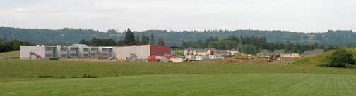 |
| Springville School and the partially-completed Arbor Oaks subdivision, as seen from the THPRD sports complex. |
The Beaverton School District (BSD) has nearly completed construction of Springville School which will open in September 2009 with room for 725 students. Note that the money to build the school was provided by the $195 million bond measure voters approved in 2006. Initially, it will provide classes for K-5 with additional grades added each year until it includes K-8. BSD Information Officer Maureen Wheeler commented, “We did consider not opening it to save money in this year of tight budgets, but plans are far enough along that we are going to open the school. We need to provide relief to some of our northern schools like Jacob Wismer that are already overcrowded.”
 |
The THPRD facility features soccer & baseball fields. Photo by Neil Hefty |
Tualatin Hills Park & Recreation District (THPRD) constructed a large sports complex on the east end of the PCC property to serve both PCC students and existing park district residents. Additional field space will need to be acquired and constructed to serve the need of future North Bethany residents. THPRD System Development Charges (SDCs) to be collected should be adequate to cover these costs.
The county’s current plans call for North Bethany to be integrated into the Bethany community, which is governed by Washington County. Special service districts, such as Clean Water Services, THPRD, Tualatin Valley Fire and Rescue and the Tualatin Valley Water District will provide many services.
Most commuters who will call North Bethany home are expected to head west and south to jobs in Beaverton and Hillsboro, but some will head east on NW Springville Road or north to NW Germantown Road and then east on their way to Portland. Cornelius Pass Road is also part of the affected transportation system and is in danger of serious failure. (Trucks hauling hazardous materials—gasoline and other chemicals—are prohibited from using Hwy 26 out of Portland due to the tunnel and Hwy 217 is off-limits, so this forces tankers to use Cornelius Pass Road instead—as if it was safer!)
Multnomah and Washington County have no plans to improve those “back roads,” said Carl Springer, a principal with DKS Associates, a road consultant for North Bethany. Springville Road, already a key east-west road that separates Bethany and North Bethany, is expected to expand from two to five lanes. NW 185th Avenue also is planned to become five lanes as far north as Springville Road. That intersection would need to be realigned slightly north to accommodate new traffic heading east on Springville.
Planning for new urban areas at this scale is unprecedented in the county, and the current funding structure to pay for new growth does not meet the needs. For North Bethany, a new approach was deemed necessary, and Washington County’s Board of Commissioners has said they will only consider a land use master plan if it comes with an adequate companion finance plan.
The funding strategy currently being considered for North Bethany requires developers to pay for approximately 66% of on-site project costs, and future residents of the North Bethany area to pay for approximately 33% of costs as part of a proposed “community service district.” A survey of county residents shows there is adequate support for this overall funding strategy.
Developers, who have been accustomed to paying more like 20% of the infrastructure costs of growth, are expressing skepticism that they can develop under these conditions. At the Stakeholder Working Group in February 2009, a presentation was given by a developer consulting group stating that the funding strategy, “Would leave a negative residual value for land; there would be no viable way to develop and sell competitive homes under this structure; and that the highest and best use of the area would be agricultural.”
It’s estimated that these charges will amount to $64,000 per home constructed whereas developers currently pay about $17,000. The overall cost of infrastructure would be more like $90,000 per home. Our State Representative Mitch Greenlick, who sits on the House Land Use committee, said he thought the total could be more like $200K per home if the true costs were born by the developers and new residents.
Reductions of financial responsibilities are being considered: a delay in implementing the new Transportation Development Tax is proposed; some North Bethany developers want to be excused from paying their full share of various SDCs; and developers could be excused from paying for “off-site” improvements to the roads that people will be using to get in and out of the area. This last item reflects the traditional system of improving roads—current and future residents will either deal with major congestion or else all the county taxpayers will pay from road funds.
The Washington County Planning Commission will hold hearings beginning in July, and the Board of Commissioners will hold hearings beginning in mid-August to approve the North Bethany master plan. More information about the plans and procedures is on a county website at bethanyplan.org.
Going forward, the Urban/Rural Reserves study process is identifying those lands which will be developed at some point in the future (Urban Reserves) and those lands which will always be undeveloped (Rural Reserves). Hopefully this process will finally create a landscape that enough county residents agree on so that the proper funding mechanisms can be created to deal with the flood of new residents coming our way.
Published monthly by Cedar Mill Advertising & Design
Publisher/Editor:Virginia Bruce
503-629-5799
PO Box 91061
Portland, Oregon 97291