 |
Previous Issues |
| Cedar Mill Community Website |
|
Search the Cedar Mill News: Search the Cedar Mill News
|
About The Cedar Mill News |
|
|||||||
| Volume 16, Issue 6 | June 2018 |
||||||
Park District News
|
|||||
 |
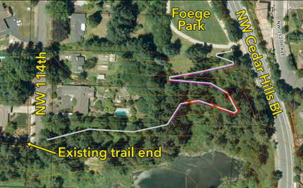
| Purchase of the wooded lot on 114th made it possible to extend the trail. |
THPRD is applying for a grant from Oregon’s Recreational Trails Program to complete the last segment of a loop that extends around the Timberland development. When it’s complete, it will provide access to Foege Park’s western segment, which has a small playground and some picnic tables. That connects via a pedestrian bridge over Cedar Hills Bl. to a trail leading to the eastern segment of Foege Park.
Letters (email is fine) of support for the grant can be sent to Brad Hauschild at bhauschild@thprd.org but they must be received by June 13. If the district is successful, planning will begin this fall and extend through 2019, with construction slated to begin in 2021. Hauschild explains that it’s a complex project because it involves steep slopes and nearby wetlands. The trail will be fully accessible and paved.
 |
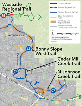
This segment is part of the Cedar Mill Creek Community Trail. According to the Trails Functional Plan, published in 2016, the trail will eventually connect with the Bonny Slope West Trail, the Westside Regional Trail, and the North Johnson Creek Trail.
As the map shows, land still needs to be acquired for some of those trails, but much of the Cedar Mill Creek trail exists. (If you’re interested in how the district acquires land for trails and other facilities, be sure to attend the July 9 CPO 1 meeting with Jeannine Rustad, THPRD’s Superintendent of Planning, who will give us insight into THPRD’s park acquisition and development priorities and policies.)
Thursday, August 9, 6-8 pm, Cedar Mill Park, 10385 NW Cornell
Seymour Band will entertain us this year at this fun, family oriented community event. Mark your calendar, and we’ll bring you more information next month!
The Tualatin Hills Park & Recreation District has updated its popular nature and trails map to help users find parks and natural areas and walk, run, ride, and roll across the 50-square-mile district.
The handy foldout features a large map of THPRD’s entire service area. It displays the district’s growing trails network by surface type and shows bike lanes, rail lines, parks, natural areas and greenways, and park district facilities. It also includes information on nature classes, wildlife watching, nature play sites, THPRD dog parks, and much more.
Printed copies are available free at all THPRD centers, at Beaverton-area libraries, and several other locations. Users will also find the map at thprd.org/trailsmap.
![]()
Like us on Facebook for timely updates
Published monthly by Cedar Mill News LLC
Publisher/Editor:Virginia Bruce
info@cedarmillnews.com
PO Box 91061
Portland, Oregon 97291
© 2018