Roads & Transit News April 2024

- Deer crossing
- Transportation Improvement Projects
- Paving and repair projects
- Comment on the Draft Road Maintenance Program
- Walker Road construction drives on
- Ordinance 900: Amendments to the Transportation System Plan
- Trimet is Moving ahead on A Better Red
Deer Crossing
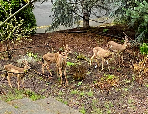
Neighbors along 119th have been concerned about a small herd of deer living around the area and the danger of cars hitting them. They wanted to know how to get “Deer Crossing” signs installed. Land Use and Transportation let us know that “The best way to have a sign like this installed is to have people submit a Request a Road Service form. This will allow us to schedule inspections for evidence of deer trails, habitat, etc.”

That form is a great way to report any kind of road hazard or issue. The department is very responsive. Potholes, hazardous debris including large animals, curb damage, missing or damaged signs–they can handle it all or at least refer you to a better source. Keep a bookmark in your browser!
For more information on how WashCo manages and uses road signs, visit this page.
Transportation Improvement Projects
Learn more about transportation projects currently in construction or design on this page. Here are some local upcoming projects.
Cornell Road Sidewalk Repair
The sidewalks on Cornell Road from Saltzman Road to Dale Avenue are damaged. LUT will replace over 3200 square feet of sidewalk panels where needed on both sides of the road.
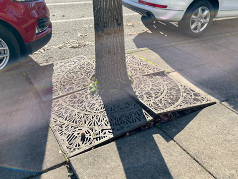
The street trees that were originally planted are not suitable for the roadside environment. Over time, they have damaged the tree grates and surrounding sidewalk. We will remove and replace them with trees from our approved street tree list.
Because the tree grates were custom built, we cannot replace them. We will fill the tree wells level to the sidewalk with mulch. The mulch will be replaced as needed.
Construction start (expected): May 2024; Construction finish (expected): June 2024. As of March 12, design work is nearing completion. Cost: $200,000 (estimate) funded by the Road Fund. For more information, contact Road Maintenance, lutops@washingtoncountyor.gov or 503-846-7623.
Thompson Road Realignment (Kenny Terrace)
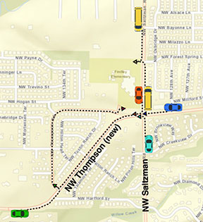
Thompson Road has two sharp curves west of Saltzman Road. LUT will connect Thompson Road to Kenny Terrace west of Saltzman Road and north of Hartford Lane. This creates a new road alignment that avoids the curves. The new alignment has three motor vehicle lanes (one travel lane in each direction and a center turn lane). We will install buffered bike lanes and multiuse (bike and pedestrian) paths on both sides of the road.
Many of the existing trees along Kenny Terrace have outgrown the space and are unhealthy. Trees are being removed due to poor condition and to accommodate the multiuse paths. We will plant more trees throughout the area than we remove. Tree species are being selected for suitability to the landscape area provided. We will also improve stormwater drainage and street lighting.
The bid opening is scheduled for Wednesday, April 3. The bid opening date was pushed back two weeks because the project manager was promoted, and a new project manager stepped in and needed to get up to speed, according to an LUT spokesperson.
Construction start (expected): May 2024 • Construction finish (expected): Summer 2025
Sign up to get email updates. (NOTE this form covers all current projects, so you need to choose which projects you want emails for.)
Paving and repair projects
The following projects are coming up this spring in the Cedar Mill and Bethany areas. Visit the web page for updates.
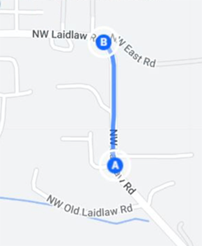
- Laidlaw Road, April 1-2,8:30 a.m.-4 p.m., Donnell Terrace to East Road;lane closures for culvert replacement.
- Cornell Road/173rd Avenue intersection; April 3, 9 a.m.-3:30 p.m. intermittent lane closures for pavement repair.
- Laidlaw Road, April 3, 8:30 a.m.-4 p.m.,Donnell Terrace to 118th Avenue;intermittent lane closures for pavement repair.
- Kaiser Road, April 1-2: from Purvis Drive to Laidlaw Road
Summer 2024 Road Projects
- Butner Road from Murray Boulevard to Downing Street
- Cornell Road from 173rd Avenue to 200 Evergreen Parkway
- Park Way from Walker Road to Cedar Hills Boulevard
In addition to road repair projects, many slurry seal projects will take place during the dry months on neighborhood and other streets. See this web page and search for streets that affect you.
Comment on the Draft Road Maintenance Program
Open house through April 21
Help shape our FY 2024-25 road maintenance activities by visiting the Draft FY 2024-25 Road Maintenance Program online open house. Please visit each of the “tables” below to learn about the Draft FY 2024-25 Road Maintenance Program. Please share your comments and questions at the Comment Here table (Table 4).
Review and comment on proposed maintenance activities. Highlights include 11.34 miles of chip seal pavement repair performed by LUT crews, 4.55 miles of paving done by contractors, four major culvert replacements, 250 miles of sweeping bike lanes and shoulders, 1,800 miles of clearing and trimming roadside vegetation.
Walker Road construction drives on
Work continues on Walker Road, with two more projects moving toward construction.
Walker Road Phase 2 (Schendel Avenue to Butner Road) is in construction through December.
Walker Road Phase 3 (173rd Avenue to 185th Avenue) is expected to start construction this fall and continue through late 2026.
Walker Road and Murray Boulevard Intersection Project is expected to start construction in summer 2025 and continue through summer 2027.
Ordinance 900: Amendments to the Transportation System Plan
Tuesday, April 2, 10:25 am, online and Charles D. Cameron Public Services Building, Auditorium, 155 N. First Ave., Hillsboro
The first public hearing for Ordinance 900 will take place early this month, followed by a vote for passage. Ordinance No. 900 (link to download a PDF, see the maps section for more info) proposes to amend the Transportation System Plan to incorporate general map and text changes for consistency with ongoing transportation planning efforts. Many of the amendments are proposed for consistency with transportation plan updates adopted by cities. The amendments also establish the alignment of the Council Creek Regional Trail and include changes to the transit system map for consistency with recent transit service provider plans. The proposed ordinance is posted on the County’s land use ordinance webpage here.
Maps that affect our area are on page 2, 20, 25 (bus lines); page 33-34 (Community Connection Areas) and page 35 (Pedestrian System Classifications from regional trail to trail refinement areas). The video of the meeting is available to view on the “Recent Meetings” tab on the right side of this page.
Trimet is Moving ahead on A Better Red
If you have missed being able to use the MAX Red Line to get to and from the airport, here’s some good news. We’re now through the last planned service disruptions needed for the project. The Gateway North MAX Station officially opened March 4. This station serves MAX Red Line trains heading from Portland International Airport toward City Center.
We wrapped up the last disruption of the project just days ago as our focus turned to the west side and extending the MAX Red Line 10 stations west. When A Better Red is complete later this summer, the Red Line will run between Hillsboro and Portland’s airport stations. That means faster and more convenient travel for riders and a better-connected west side.


