

Roads News June 2024
- Thompson Construction Update
- Work Beginning on Cornell Road Sidewalk Repair
- Weeds in the Medians
- Cornell Congestion
- 130th and the New Subdivision
- Hall Boulevard Overpass Across 217 Closed for Nine Months
- DMV and the County Lne
- Walker Road Phase 2: Schendel Avenue to Butner Road
- MSTIP 3f projects
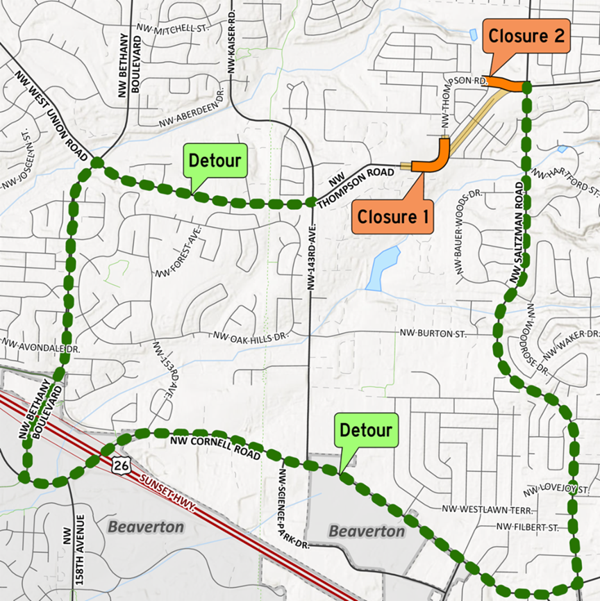
Thompson Construction Update
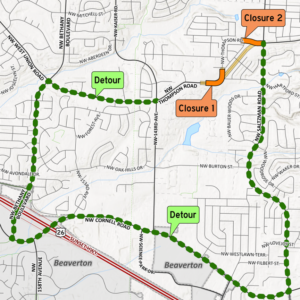
Thompson Road will be connected to Kenny Terrace west of Saltzman Road. The new connection will eliminate the existing sharp curve. The new Thompson Road connection will be a three-lane road (one travel lane in each direction and a center turn lane) with bike lanes, multiuse (cyclist and pedestrian) paths and landscaping.
Construction begins this month and is expected to continue through February 2025. Two closures of Thompson Road are planned:
Closure 1: West of the curve, for about 45 days between June 15-Sept. 1.
Closure 2: West of Saltzman Road, for about 30 days in the fall.
[Ed. Note: we had previously been told that the second closure would come first to avoid disrupting Findley Elementary student dropoff.]

Drivers will be detoured to Saltzman Road, Cornell Road, and Bethany Boulevard. Cyclists, pedestrians, and local traffic may use local routes. See map.
[Ed. Note: many people notice that there are a few shorter ways to get around the closures, but Heather Sturgill, Senior Communications Specialist at LUT, notes “Thompson Road is an arterial and designed to handle more traffic than 143rd Avenue, which is a collector. Detour routes use streets of the same classification or higher. See our Road Classification Infographic for more information.”]
The $7.48 million project is funded through the MSTIP Bonding Cost-sharing Program for improvements in the North Bethany/Bonny Slope West area.
Work Beginning on Cornell Road Sidewalk Repair
Construction on a repair that will replace over 3200 square feet of sidewalk on Cornell Road from Saltzman Road to Dale Avenue is scheduled to begin Monday, June 3.
The sidewalks were damaged by trees that were planted as part of a County project in 2007. The trees species are not appropriate for the size of the tree wells and have damaged the tree grates and surrounding sidewalk. The County has since updated its approved street tree list with species suitable for the roadside.
The trees will be replaced as part of the project. The County consulted an arborist who determined that the trees need to be removed to bring the sidewalk into compliance with the Americans with Disabilities Act. Other solutions like only cutting the roots of the trees that were damaging the sidewalks would kill them.
Cast-iron tree grates will be removed by the contractor and sold for scrap. Pedestrian access will be maintained during construction and no traffic impacts are expected on Cornell Road. Construction is scheduled to finish June 19. Schedules are subject to change.
Weeds in the Medians
Washington County put landscaped medians in several of our area roads as part of road improvement projects. In the past, the county maintained them, sending landscapers out to get rid of weeds.
Saltzman medians
We tried to get the Road Maintenance Department to take care of them again this year, but they say it’s no longer their responsibility. They only work on landscaping that encroaches in the roadway or is otherwise a safety hazard. We hope that the adjacent Homeowners Associations (HOAs) for Bauer Crest, Bauer Oaks, and other subdivisions will take this on at least for the overgrown and unsightly median in Saltzman. IF you are a member of those HOAs, let your board know.
The recent Cornell Cleanup performed by members of the Cedar Mill Community Club focused on trash and debris on the sidewalk and curb areas. We may try to schedule another session to focus on the weeds, and pruning and maintaining the trees, after the sidewalk repair has been completed.
The county has an Adopt-a-Landscape program that gives some support to neighbors who want to maintain common areas. If you know of other weedy areas in the public Right of Way, please ask the adjacent HOA (if any) about taking it on. Or reach out to neighbors to organize a cleanup. Nobody else is going to handle it, and it’s not a good look!
Cornell Congestion
Neighbors are continually dismayed by heavy traffic along Cornell in both directions during morning and afternoon “rush hour.” Some have asked about coordinating the lights to improve the flow of traffic. We asked Washington County Land Use & Transportation about that and here’s their response:
Traffic congestion on Cornell Road, between Murray Boulevard and Saltzman Road, is primarily due to limited capacity and increased demand. This section of Cornell was to be widened many years ago in anticipation of the vehicle demands we now see, but the community was not supportive of this. Instead, the town center is limited to one-lane in each direction to better support pedestrians and cyclists, creating a smaller town feel.
We continue to fine-tune timing along Cornell to better balance demands. The Cornell and Barnes intersection is a bottleneck point and current signal timing allows us to ramp up more green time for the critical eastbound traffic as needed, while balancing delays for side-street and pedestrian traffic. The trade-off is loss of coordination along Cornell Road between Murray and Saltzman. Once traffic backs up between traffic signals, coordination is lost due to wide variations in speed between the signals.
An eastbound right-turn lane at Cornell and Barnes would help with the bottleneck, but we don’t have funding for this improvement. Reducing the queuing at Cornell and Barnes would also reduce delays at Murray and Cornell.
Our traffic engineers will continue to watch the area and refine the timing as possible.
130th and the New Subdivision
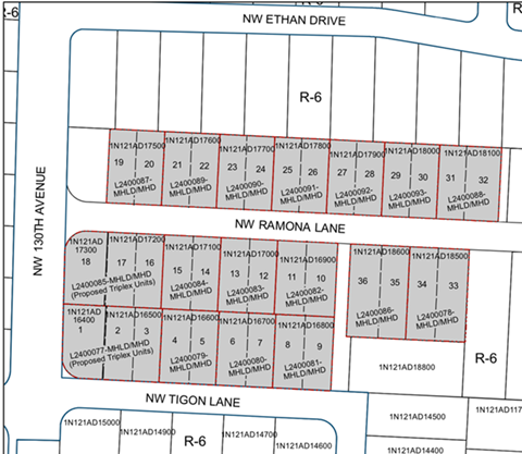
A proposed development, “Riverside at Deer Fern Ridge” in CPO 7, has added density to the original proposal by converting some of the lots to “Middle Housing” which will increase the number of dwellings. The property is adjacent to 130th, which should eventually be connected at Laidlaw to the proposed new alignment of Saltzman. Right of Way to make the road wider was dedicated in a previously approved application. The CPO 7 past chair, Mary Manseau, has requested a stipulation in the approval that would prevent future property owners from objecting to the formation of a Local Improvement District (LID) to improve the road in the future.
The development is listed on the “Comment on a Project” page as Case File L2400077 while it is under review by county planners.
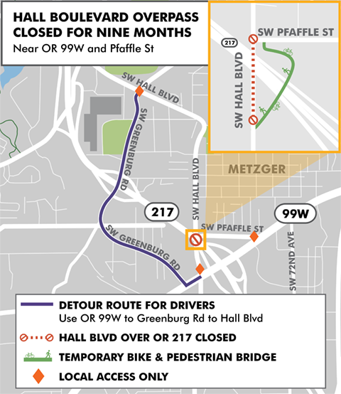
Hall Boulevard Overpass Across 217 Closed for Nine Months
Crews have been working hard to improve safety and reduce bottlenecks on OR 217 by adding auxiliary lanes, or ramp-to-ramp connections, between Beaverton-Hillsdale Highway and OR 99W. To make room for these new auxiliary lanes and safety shoulders on the south end of the project, the Hall Boulevard overpass in Tigard near OR 99W and Pfaffle Street will be replaced with one that is longer and includes wider sidewalks and bicycle lanes.
To build the new structure, the overpass is closed to traffic for nine months as of March 4, 2024. A bike and pedestrian crossing is available throughout the closure.
DMV and the County Line
Some of our neighbors noticed that they had been charged Multnomah County rates when they renewed or initiated vehicle registrations at local DMV offices. It was likely done because most of us have a Portland zip code and the attendant and the customer failed to notice the discrepancy.
We spoke to a DMV representative who encouraged those who had been overcharged to bring their registration to the office. Apparently the situation has been remedied and the clerks are now watching for the situation. If you feel you were charged in error, make an appointment (highly recommended) and take your registration receipt to the office where you paid.
Walker Road Phase 2: Schendel Avenue to Butner Road
This ongoing project will widen Walker Road between Schendel Avenue and Butner Road to five lanes, two travel lanes in each direction and a center turn lane, with continuous bicycle and pedestrian facilities. Storm drainage will be upgraded and additional street lighting will be installed. This is the second phase of capacity improvements to Walker Road. A separate project expands the Walker Road/Murray Boulevard intersection.
The traffic signal at Walker Road and 158th Avenue will be shutdown 9 am-3:30 pm from May 28-June 7. Traffic will be controlled by flaggers. Expect delays. We are temporarily limiting traffic at driveways along Walker Road, starting at 150th Avenue and working toward Butner Road. Retaining wall and stormwater pipeline installation is on-going.
MSTIP 3f Projects
The Major Streets Transportation Improvement Program (MSTIP) is a one-of-a-kind program in Oregon. Since its inception in 1986, MSTIP has resulted in the investment of more than $1 billion in local funds toward the construction of a robust, interconnected, and multimodal transportation system using countywide property tax revenues to support our growing county. The program has also helped leverage additional regional, state, and federal funds.
The total proposed MSTIP 3f allocation is $250 million, based on potential revenues over a five- to sixyear timeframe. Approval for the final tranche of project funding will be requested during the June 5 meeting of the Board of County Commissioners.
The only projects near Cedar Mill on this list are two projects to widen Walker Road between Park Way and Highway 217.


