

Road News December 2020
- Saltzman Road PAC recommends western alignment
- Comment now on changes planned for Highway 217
- Expansion of Neighborhood Streets Program
- Comment on the Walker Road Phase 3 Project
- Cornell/Barnes turn lane on county budget
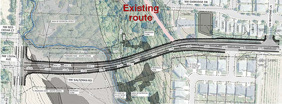
Saltzman Road PAC recommends western alignment
Vicky Siah, CMN student intern
The fourth and final Saltzman Road Public Advisory Committee (PAC) meeting was held on November 4. The group consensus was to forward a recommendation for the western alignment.
During the public input segment, Jake Krishnan asked the county to assess the feasibility of each alignment as “both options seem to be untenable in some way, shape, or form.” Suresh Bala voiced a similar concern—if the county proceeds with the western alignment, the potential time delay in permitting may lead to inconveniences. County Engineer Ben Lively addressed both Bala and Krishnan’s comments, noting that the project requires approval from Clean Water Services, the Department of Fish & Wildlife, and the US Army Corps.
Feasibility became a guideline during the PAC member discussion. Virginia Bruce opened a debate on environmental impacts. Given the substantial spacing between pillars on the western alignment bridge option, she questioned an earlier opinion that the western alignment would be more detrimental to surrounding wildlife. The roadway on the eastern alignment causes habitat fragmentation that may prove more harmful to animals than the noise pollution under the proposed western bridge. PAC members Asif Rahman and Mary Manseau mentioned that an initial discussion on habitats should have taken place when housing was being constructed in that area. Replacing a culvert with a pedestrian bridge, lowering banks, improving creeks, and coordinating roadwork with THPRD may mitigate effects on ecosystems.
Alternative routes from TVF&R and the Sheriff’s Office must be simultaneously factored. Trace Richards from TVF&R weighed in by reinforcing TVF&R’s adaptability to road closures. However, if the current road is terminated, TVF&R asks for a turnaround to accommodate for their apparatus.

Bruce Barbarasch, who represents THPRD, illustrated THPRD’s position as favoring the eastern alignment. “Maintaining two roads force more water runoff from hard surfaces,” he claimed. THPRD says the eastern alignment preserves the possibility of building a local park.
Virginia Bruce mentioned Washington County’s 2004 Ordinance 626, which expressed the county’s interest in provisioning for a northward extension of Saltzman to Springville Road, which could be useful in later years. The western alignment is clearly compliant, but the eastern alignment would involve a tricky detour on Laidlaw.
Following PAC member comments, discussion facilitator Brandy Steffen from JLA Public Involvement shared the PAC member responses indicating first and second preferences. The three options were the western alignment, eastern alignment, and “no build” (which specifies that the current Saltzman Road alignment will be left unchanged). Six out of eight PAC members voted western alignment as their first choice, and two members designated the western alignment as their second preference. Two members indicated the eastern alignment as their first preference, and four members listed that the eastern alignment would be their second preference. The “no build” option was the second preference of two PAC members.
Since over two-thirds of members voted in favor of the Western alignment, that recommendation will be forwarded to the Washington County Board of Commissioners.
The added expense of the western alignment may be a factor when the Board considers the issue. The recommendation of the PAC is not binding. Once the issue comes to the Board, we’ll let you know and community comments may be helpful.
More information about the Saltzman Road realignment decision-making process and the Board Public Comment Hearing can be found here.
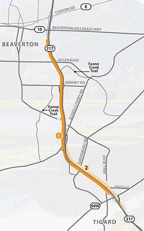
Comment now on changes planned for Highway 217
Open House available for comments through December 17 online
The OR 217 Auxiliary Lanes Project will address long-standing bottlenecks on the highway between Beaverton-Hillsdale Highway and OR 99W due to too many closely spaced interchanges. Auxiliary lanes are ramp-to-ramp connections that help reduce bottlenecks by giving drivers more space and time to merge safely. This decreases conflicts, improves safety and the flow of traffic, and ultimately allows the existing lanes to work more efficiently.
We will also address one of the worst bottleneck locations at the Allen Boulevard and Denney Road interchanges by removing two ramps and adding a new frontage road. Other major elements include replacing a bridge structure and building four sound walls.
We aren’t just making improvements to the highway itself. We also need to make the area surrounding OR 217 safer for all users. In partnership with the City of Beaverton and Washington County, we are making targeted improvements to local bicycle and pedestrian routes
At this online open house, you can:
- Hear from the project team and partners.
- See an interactive map of the project.
- Learn about auxiliary lanes and how they improve safety.
- Learn more details about the anticipated traffic impacts.
- Provide comments and more!
Anticipated traffic impacts
We know more about what types of traffic impacts people will encounter during the four-year construction project, starting in late 2021. Construction will happen in phases and the sequencing and detailed schedule will be communicated as the project progresses. Detour routes will be established in partnership with local jurisdictions. In addition to nighttime lane and ramp closures, anticipated traffic impacts over the life of the project include:
- 24/7 single lane closures for up to nine days at a time (this will happen twice; once near Scholls Ferry Road and once near OR 99W) and up to two days at a time (this will also happen twice; once near Greenburg Road and once near Denney Road).
- Full closures of one direction of OR 217 for up to five weekends.
- Up to five-month closure of the southbound on/off ramps at Denney Road before the new frontage road is open.
- Up to two-month closure of northbound entrance loop ramp from OR 99W.
- Up to six-month closure of the Hall Boulevard overpass between OR 99W and Pfaffle Street. A bike/pedestrian temporary bridge will be available during the closure as well as a signed detour for drivers.
- Lane closures on local roads adjacent to OR 217.
There are more details about these impacts at the online open house.
Learn more about auxiliary lanes, specifics on the project elements, anticipated traffic impacts, and submit your questions or comments to the project team by visiting the online open house now through December 17, 2020.
Expansion of Neighborhood Streets Program
The County Board approved an expansion of the Neighborhood Streets Program (NSP) at their November 17 meeting. The program helps maintain livability in urban unincorporated neighborhoods by addressing traffic-related quality of life issues, such as speeding and parking infiltration.
The NSP is a traffic-calming program designed to help reduce speeding and improve safety on neighborhood streets within the Urban Roads Maintenance District (URMD), which encompasses urban areas outside cities. The NSP expansion increases potential program eligibility by reducing the minimum speed threshold from 7 mph to 5 mph over the speed limit. The expansion also allows some “residential collectors” to be NSP eligible. These are roads that are classified as “collectors,” which collect the traffic traveling between neighborhoods, but look and feel more like local streets.
Expanding the NSP is good for our neighborhoods, said Melissa Norman, NSP Coordinator and Transportation Engineer. “Thanks to the expansion, we will be able to help neighborhoods that have asked for help previously, but did not qualify.”
Traffic-calming options include lawn signs, speed trailers, and a community-driven safety program to reduce speeding. Community involvement is an important part of all traffic calming projects. The people who live and work in the project area have the opportunity to become actively involved in the process. A safety campaign includes:
- Meeting with a neighborhood to identify concerns
- Identifying and implementing initial safety measures
- Reviewing impact of initial safety measures and determining if further safety measures are needed.
To learn about the safety program, visit the NSP webpage or email lutnsp@co.washington.or.us.
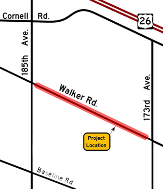
Comment on the Walker Road Phase 3 Project
Online Open House through December 13
Walker Road will be widened to five lanes (two travel lanes in each direction with a center turn lane) with bike lanes and sidewalks between 173rd and 185th avenues. The project also includes:
Replacement of a culvert at Willow Creek; Removal of a dip in the road at the culvert; Installation of a traffic signal at the Walker Road and 178th Avenue/Cambray Street intersection; Installation of soundwalls; and Improvements to drainage and street lighting.
The $10.5 million project is funded through the County’s Major Streets Transportation Improvement Program (MSTIP 3e).
To participate, visit the Walker Road Phase 3 Open House or contact Capital Project Services at 503-846-7800 or lutproj@co.washington.or.us.
Cornell/Barnes turn lane on county budget
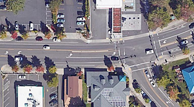
A line item in a Transportation Development Tax amended project list for approval at the December 1 Board of Commissioners meeting seems to indicate that the county is going ahead with the project to add a right turn lane from Cornell eastbound to Barnes southbound.
“Add eastbound right-turn/bus bypass lane on Cornell at Barnes, ADA curbs, modify traffic signal.” The listing gives a cost estimate of $1,500,000. We were unable to find more information, and the project is not actually funded or on the county schedule.


