Were Portland’s founders drunk when they laid out the Multnomah/Washington County border?

by Marty Smith by permission from Willamette Week
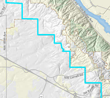
Since lockdown, I’ve been using Google Earth to take virtual tours of the world. In so doing, I noticed that Multnomah County’s western border is quite odd. Zigzaggy, if that’s a word. Were our founders drunk when they laid it out or what?
—Desktop Globe-Trotter
I’m not sure what it says about humanity that, when we get hold of a tool that allows us to effortlessly inspect literally any spot on the planet, the first thing 99 percent of us do is look at our own house. At least you zoomed out to the county level, Globe-Trotter—I guess that’s something.
I’ve half-noticed this stair-step-like border for years. But now that I think about it, wouldn’t it have been easier to just draw a diagonal line about two miles east of Forest Park and call it a day?

Spoiler alert: No. This painfully rectilinear border is a living remnant of the Public Land Survey System dreamed up centuries ago by Thomas Jefferson to bring order to America’s unruly frontier.
Also known as the Township and Range system, the PLSS imposed a grid of six-mile-square “townships” on pretty much the entire American West.
Each township was subdivided into 36 one-square-mile sections, which were in turn divided into 160-acre quarter sections. That grid of farm fields you see when you’re flying over the plains (often with circles inside them from center-pivot irrigation systems) is mostly made of quarter sections.
In practice, quarter sections were often further subdivided into “quarter-quarters” of 40 acres, which is why farmers in movies (and maybe even in real life!) are always talking about the “south 40.” This convention is also the origin of the 40 in “40 acres and a mule,” the (broken) promise made to freed slaves during the Civil War.
One of the advantages of this system is that it allows you to divvy up land that you haven’t even seen yet—all you need is one set point at the center of the grid. Around here that point was the “Willamette Stone,” a marker up in the West Hills that you can see to this day.
In any case, as you’ve probably guessed by now, the stair-step border just follows the edges of the sections in that area. More importantly, we got through a whole column without mentioning the coronavirus. You’re welcome.

Marty Smith is the brains (or lack thereof) behind Dr. Know and skirts the fine line between “cultural commentator” and “bum” on a daily basis. He may not have lived in Portland his whole life, but he’s lived in Portland your whole life, so don’t get lippy. Send your questions to dr.know@wweek.com


