

Redistricting: A Rep of our own?
By Vicky Siah (research) and Virginia Bruce (opinion)
How the census data affects Cedar Mill
By the numbers
Challenges and constraints of redistricting
Opportunities for Public Involvement
In September 2020, Cedar Mill News encouraged residents to complete the 2020 census. The result of that census shows that Oregon is due for changes in both state and federal congressional and legislative boundaries—and this month, lawmakers are soliciting public input on how to best draw new districts.
How the census data affects Cedar Mill
State and Federal House districts are supposed to represent roughly equal numbers of people. As population grows in some areas and shrinks in others, adjustments must be made. That’s what redistricting is all about. Oregon Senate districts are made up of two House districts, so the boundaries will change according to redrawn House districts.
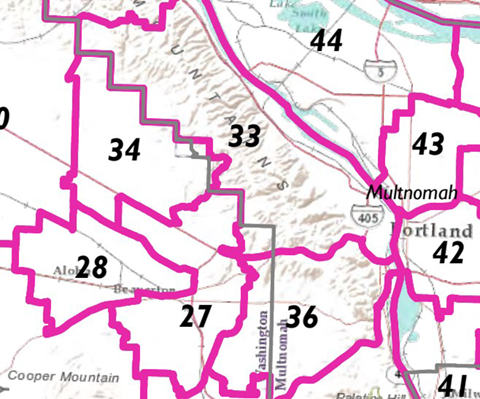
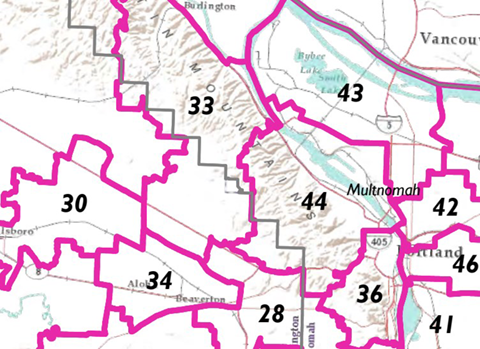
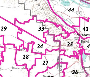
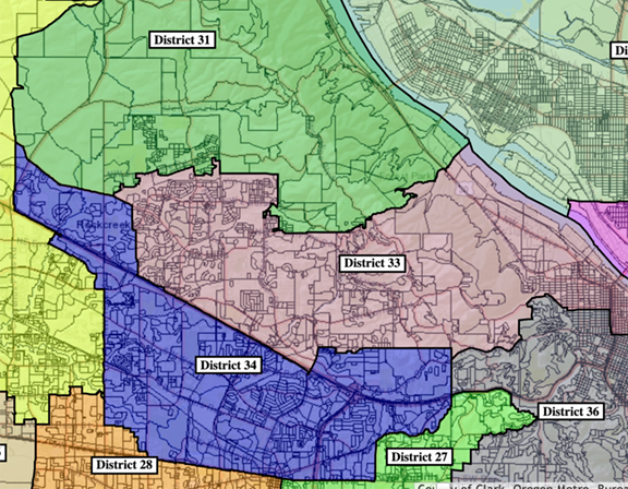
In the Oregon House, Cedar Mill (a mostly urban unincorporated area (UUA) of Washington County) is primarily represented by Maxine Dexter (District 33). She also represents some of the Pearl District and Forest Heights which are both in the City of Portland. Lisa Reynolds represents the portion of Cedar Mill in District 36, which also includes Beaverton and some of Raleigh Hills (UUA). Ken Helm (District 34) represents some of Hillsboro as well as Rock Creek and other “North of 26” UUAs. This means that our concerns, as people living not in any city but in the urban unincorporated areas of Washington County “North of 26,” are split among several representatives, all of whom also represent city dwellers. While Rep. Dexter has been very responsive and interested in learning about our issues, some of our concerns are actually opposed to those of people living in The Pearl—for example the lack of road capacity getting over the hill into Portland.
On September 3, maps proposed by the legislative committees were published here. All three maps split Cedar Mill into two or more Representative Districts. Public participation is vital in making our needs known to the legislators!

We’re not sure how this might be improved through redistricting, but it’s definitely time to try. Use the mapping feature listed below under “opportunities for public involvement” and see if you can figure it out! And please attend as many of the sessions listed there as you can. The solutions to some of our issues are definitely in the hands of the state legislature and many of us think we deserve a united voice. COVID gave us a very short window for providing input (the census data wasn’t released until August, for example) but we shouldn’t wait another ten years to improve the situation.
By the numbers
The 2020 census shows that HD33 exceeded the average House District population of 70,621 individuals by almost 11,000 people, and SD 17 (currently Elizabeth Steiner Hayward) displays a similar growth pattern. Congressional District 1 (currently Representative Suzanne Bonamici) is also a high growth area and will likely be altered.
US Congressional District 1 had the highest population increase in Oregon, surpassing the Average Oregon Congressional District Population (706,209 individuals) by 157,843 people. Each of Oregon’s five Congressional districts has seen population growth of over 110,000 individuals, and the total population qualifies Oregon for an additional Congressional seat.
Due to these increases, both HD33 and SD17 must shrink in area to meet their district averages. Some communities will move into other districts. There will also be changes in Congressional District assignments. The five current Congressional Districts will shrink to comply with the district average, and a portion of Oregon will be reassigned to the new HD6.
Challenges and constraints of redistricting
Congressional and Legislative Districts must comply with ORS 188.010, which outlines redistricting criteria:
1. Each district, as nearly as practicable, shall:
(a) Be contiguous;
(b) Be of equal population;
(c) Utilize existing geographic or political boundaries;
(d) Not divide communities of common interest; and
(e) Be connected by transportation links.
2. No district shall be drawn for the purpose of favoring any political party, incumbent legislator or other person.
3. No district shall be drawn for the purpose of diluting the voting strength of any language or ethnic minority group.
4. Two state House of Representative districts shall be wholly included within a single state senatorial district.
ORS 188.010(2) and ORS 188.010(3) offer Oregonians protection against gerrymandering, but ORS 188.010(1) heavily relies on the relationship each Oregonian forms with their surroundings.
Complying with ORS 188.010(1) is a significant challenge—to ensure that communities of common interest remain intact, each Senator and Representative must develop a thorough understanding of their communities’ cultures, networks, and interactions. Factors such as ethnicities, relationships to natural features, infrastructure, economy, political beliefs, town designations, and more all contribute to redistricting.
“As one of the fastest growing areas in the state, HD 33’s district borders will become smaller, which means we need to identify and take into account communities of common interest, as well as what changes should and should not be considered,” Rep. Maxine Dexter said. “This is especially important because redistricting affects how our government and organizations allocate resources and public funding, including education, healthcare, transportation, emergency response services, as well as how communities’ voices are reflected and represented in government.”
If lawmakers are unable to provide a final redistricting map by September 27, the task of redistricting will shift to the Secretary of State—a position currently held by Shemia Fagan. To prepare for this possibility, Secretary Fagan collected applications for a People’s Commission—a panel of public commissioners—to contribute their personal experiences. This commission would play a purely advisory role (should redistricting proceed to Secretary Fagan), but nevertheless, it has the potential to shape Oregon’s Legislative and Congressional Districts.
These concerns were reflected in the previous 2011 redistricting effort. Public hearing topics included agricultural sales, port access, railways, and more. In a series of joint meetings, the Senate and House considered the implications of new district map designs, and on June 10, 2011, the map passed both legislative votes. 2011 was the first redistricting since 1981 in which redistricting duties did not transfer to the Secretary of State.
Opportunities for Public Involvement
Through town halls and public hearings, Oregon lawmakers will solicit testimony from their constituents, using this input to inform their decisions. Testimony can be delivered orally or through writing, and those interested in oral testimony can register for a public hearing session. Residents of Cedar Mill can also discuss redistricting with Representative Dexter at her Town Hall meeting.
Public hearings are being held virtually for all areas. Instructions for joining the meetings are on the Redistricting Page. Although they are delineated by Congressional District, each meeting will consider all three types of redistricting. Draft maps created by the House and Senate Interim Redistricting Committees are now available on the state website.
- Congressional District 1: Wednesday, September 8, 8 am; Thursday, September 9, 5:30 pm
- All Congressional districts: Monday, September 13, 1 pm and 5:30 pm
- HD 33 Town Hall: Tuesday, September 7, 6:30 pm, register here
Written comments should be emailed to Oregon.Redistricting@Oregonlegislature.gov. All comments must be sent by 5:30 pm on Tuesday, September 14, and residents must include their Congressional District number in their email’s subject line.
Residents can view publicly submitted maps and create a map proposal through the Oregon government’s redistricting software by Tuesday, September 7 at 5 pm. The redistricting website provides resources for those interested in submitting a map, including a walk-through manual, video tutorials, integrity tests, and a map submission checklist. Maps submitted through this application will be made available to the public and open for comment.
We’ll be discussing this at the September 14 CPO 1 meeting as well. Get the Zoom link and more details here.


