

Road News September 2021
- Cornell Road closing through the tunnel
- Thompson Road realignment
- MSTIP 2023-2028 Funding Allocation Process Work Plan is in progress
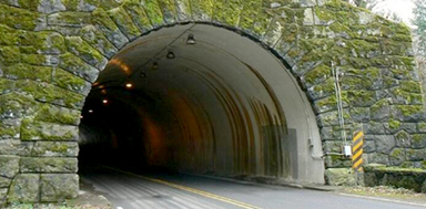
Cornell Road closing through the tunnel
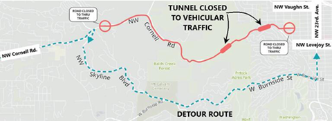
Beginning on Monday, August 30, contractors for the Portland Bureau of Transportation (PBOT) closed NW Cornell Road between NW 30th and 53rd avenues for essential repairs to the Cornell Tunnels to prevent structural failure and to extend the tunnels’ lifespan. Eastbound traffic will be detoured to NW Skyline Boulevard. Westbound traffic will be detoured from NW 23rd Avenue to West Burnside. The detour is expected to be in place for the duration of construction which is estimated to be complete in Spring 2022.
A large crack near the crown of the western Cornell Tunnel was observed during recent inspections. An in-depth field assessment in 2019 and subsequent geotechnical engineering report recommended tunnel lining strengthening to prevent structural failure of the tunnels. This project will provide the recommended tunnel lining strengthening and lining coating and considerably extend the useful life of the tunnels.
Traffic will be detoured via NW Skyline Boulevard and West Burnside Street through Spring 2022. Access to Portland Audubon and the Upper Macleay trailhead will remain open with access from Skyline. The project web page, with a link to sign up for project updates, is here.
The road will remain open to pedestrians and bikers, who will be directed to use the existing paved paths that go around the tunnels. Local access will be maintained for residents and businesses located along the corridor, including the Audubon Society and Adams Community Garden.
Thompson Road realignment
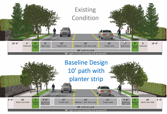
A community meeting was held on August 31 to update neighbors on the county project to realign Thompson Road west of Saltzman to eliminate the two right-angle turns. Neighbors in the adjoining subdivision have been very concerned that the county’s plan will eliminate most or all of the street trees that were planted along the route, which is currently called Kenny Terrace. The trees were planted in 2002 when the Arbor Creek at Bauer Meadows was developed and are now tall enough to provide shade along the sidewalks. Arborists hired by the county said the trees had some disease and their roots might damage the sidewalk.

The county wants to create a wide multi-use path to accommodate pedestrian and bicycle travel. They cite the commercial area at the Thompson/Saltzman corner, the park that will eventually be developed at the opposite corner, and Findley Elementary as destinations that would be served by a broad path on both sides of the road. Choices included a curb-tight ten or nine-foot path with planting nearer the houses, or a ten-foot path with a four-foot planter strip next to the road. All options will include a 7’6” buffered bike lane.
During a tightly controlled session, where only the questions chosen by staff were visible to participants and the participants were unable to see other attendees, approximately 26 neighbors expressed concerns about whether the wide path was needed; whether the sidewalk would eventually extend along Thompson to Hartung Farms, and whether a planted strip could be installed in places along the center turn lane. The PowerPoint presentation, transcript of the Zoom Q&A function, and the meeting recording are available on the project website.
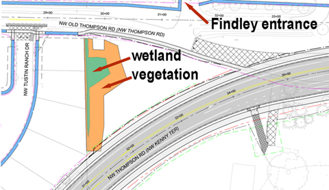
Toward the end of the meeting, staff noted that access to Findley Elementary for the families east of Saltzman Road would be via the long way around. From the Saltzman/Thompson intersection vehicles would travel along the new alignment, turn right on Old Thompson near the fire station, and then travel to the existing school entrance using the old Thompson alignment.
Beaverton School District Planner Steven Sparks says, “We have met with WaCo several times to review a few design options over the past couple of years. The County shared this design with us a few months ago. We do not have any concerns. If there are issues with people using the eastern lot, we will address those issues with the parents at the time.” Tustin Ranch Drive will be blocked at the northern end to prevent cut-through traffic.
The Board of County Commissioners will consider the alternatives proposed by LUT staff at their September 7 Work Session. The Board does not take formal action during a Work Sessions, and there is no public comment period. Work Sessions are available for live streaming on the Washington County YouTube Channel.
Another Open House will be held in November, presumably to show the neighbors what the county has decided. If the decision is made soon, construction is expected to be completed summer 2022.
MSTIP 2023-2028 Funding Allocation Process Work Plan is in progress
by Vicky Siah
MSTIP (Major Streets Transportation Improvement Program) is a series of improvements that Washington County makes to the transportation system in five-year cycles. The current MSTIP cycle ends in 2022. Through September 2022, a MSTIP project work team, a technical work group, the Washington County Transport Advising Committee (WCCC TAC), Washington County Coordinating Committee (WCCC), and Board of Commissioners will develop and approve the MSTIP 2023-2028 Funding Allocation Process Work Plan. Upon implementation, the MSTIP plan directs funds from countywide property taxes to transportation projects selected for funding.
The Department of Land Use and Transportation (LUT) looks to incorporate public input alongside recommendations from the WCCC and the Board of Commissioners. This process is broken into four phases:
Phase 1 (August 2021-February 2022): Public outreach will focus on learning what the community values to inform the work plan’s goals and develop metrics for project evaluations. LUT will solicit project suggestions from local jurisdictions and draft financial targets based on input.
Phase 2 (February-March 2022): All suggested projects will be scored with the project evaluation metrics. The list of projects will be narrowed down.
Phase 3 (March-August 2022): The public will be asked to comment on the project list from Phase 2. The project list will be further refined; MSTIP administrative procedures will be updated for contracting and amendments.
Phase 4 (August-September 2022): Phase 3’s project list, funding allocation list, and administrative procedures will be delivered to the Board of Commissioners for approval.
LUT lists the desired outcomes of MSTIP 23-28 as equity, safety, environmental vitality, livability, and minimizing impact to the natural environment. To reach these goals in a timely manner, project organization remains an ongoing effort from Phases 1 to 4. Each of the five teams (project work team, technical work group, WCCC TAC, WCCC, and Board) reviews work from the other teams and provides recommendations up the chain of command.
More information on the MSTIP Funding Allocation Process Work Plan will be released in the near future. Community Participation Organization (CPO) 1 will host LUT in the fall to discuss the work plan process, and as LUT solicits public opinion to aid them in development, MSTIP 23-28 will be a recurring topic as the year progresses.


